Old Saigon Building of the Week: The Lost Paris Foreign Missions Society Chapel

The interior of the MEP Chapel

This article was published previously in Saigoneer http://saigoneer.com

Hidden behind the Department of Foreign Affairs building at 4-6 Alexandre de Rhodes is the last surviving relic of that neighbourhood’s long association with the Roman Catholic Church – an abandoned chapel of the Paris Foreign Missions Society.

Rue de l’Évêché (Bishopric street), now Alexandre de Rhodes street

The street known today as Alexandre de Rhodes first came into being in 1870, during the construction of the first Bishop’s Palace. Not surprisingly, its earliest name was rue de l’Évêché (Bishopric street).

Built between 1869 and 1877 at 6 rue de l’Évêché, that first Bishop’s Palace is said to have replaced a “confiscated Annamite mandarin’s house” on rue Lefèbvre (modern Nguyễn Công Trứ street), which had served as a temporary episcopal residence since the time of the French conquest.

On 28 January 1897, the rue de l’Évêché was renamed rue Colombert, after Monsignor Isidore Colombert, who served as Apostolic Vicar of Western Cochinchina from 1873 to 1894.

A 1920s view of the second episcopal residence – the current Archbishop’s Palace – at 180 rue Richaud

However, for reasons which remain a mystery, it was subsequently decided to relocate the Bishop’s Palace to what is now District 3. In 1911, a new episcopal residence – the current Archbishop’s Palace – was inaugurated at 180 rue Richaud (modern Nguyễn Đình Chiểu). As soon as the old building at 6 rue Colombert had been vacated, it was taken over by the Cochinchina government’s Political and Administrative Affairs Inspectorate (Inspection des Affaires politiques et administratives).

At around the same time as the diocesan administration vacated 6 rue Colombert, the Paris Foreign Missions Society (Société des Missions Étrangères de Paris, MEP) built a representative office (Procure des Missions Étrangères) right next door at 4 rue Colombert. The MEP would remain there for the rest of the colonial period.

A surviving photo of the former MEP building, taken in the late 1950s when it functioned as the National School of Public Administration (Trường Quốc gia Hành chánh)

It’s said that on the morning of 23 September 1945, the Provisional Executive Committee of the South under Trần Văn Giàu (1911-2010) met in its offices to plan a campaign of armed resistance against General Gracey’s British troops and the French prisoners of war they had released and rearmed.

Following the departure of the MEP from Saigon in 1954, its former headquarters building was taken over by the government of the Republic of Việt Nam and transformed into the National School of Public Administration (Trường Quốc gia Hành chánh), while the old episcopal residence next door became the ROV Ministry of Foreign Affairs (Bộ Ngoại giao).

Five years later, the School was relocated to 10 Trần Quốc Toản (now 3 Tháng 2), permitting the ROV Ministry of Foreign Affairs also to take possession of the old MEP building. Then in 1961, both of the old church buildings at 4 and 6 Alexandre de Rhodes were demolished and replaced by a single large modern one. Since 1975, this has served as the offices of the Hồ Chí Minh City Foreign Affairs Department (Sở Ngoại vụ Thành phố Hồ Chí Minh).

The 1961 Foreign Affairs Ministry (now Department) building which replaced the two church buildings at 4 and 6 Alexandre de Rhodes

Remarkably, one relic survived the demolition of the old MEP building, and this still stands today in the rear yard of the Foreign Affairs Department compound.

Used for many years as a storeroom, the former MEP chapel at 4-6 Alexandre de Rhodes is similar in style to the chapel which stands in the compound of the Children’s (former Grall) Hospital. Although it has not yet been formally dated, it is believed to have been built during the construction of the MEP compound in 1912.

Despite its diminutive size, the chapel incorporates a transept and a small rear balcony area, the latter accessed by a spiral staircase. Sadly, the original floor of the chapel has been lost and its stained glass windows have sustained some damage, but other interior decorative work remains intact.

It’s understood that the future of the chapel hinges on a decision regarding its ownership.

An external shot of the MEP Chapel

The lobby of the MEP Chapel

The view down the nave of the MEP Chapel

The apse of the MEP Chapel, which incorporates its largest stained glass window

Looking back towards the entrance the MEP Chapel – note the balcony, currently boarded up

One of two east transepts in the MEP Chapel

One of two west transepts in the MEP Chapel

Part of the ceiling of the MEP Chapel

Another external view of the MEP Chapel

The west side exterior of the MEP Chapel

Tim Doling is the author of the guidebook Exploring Saigon-Chợ Lớn – Vanishing heritage of Hồ Chí Minh City (Nhà Xuất Bản Thế Giới, Hà Nội, 2019)

A full index of all Tim’s blog articles since November 2013 is now available here.

Join the Facebook group pages Saigon-Chợ Lớn Then & Now to see historic photographs juxtaposed with new ones taken in the same locations, and Đài Quan sát Di sản Sài Gòn – Saigon Heritage Observatory for up-to-date information on conservation issues in Saigon and Chợ Lớn.

The Lippmann Affair

The place des Cocotiers (Petit Lac) tramway interchange in 1952

Demoted and then sacked by the Vichy authorities for being Jewish, Hanoi Tramways Company director Léo Lippmann spent several years trying to get his job back.

The anti-Semitic statutes passed by the French Vichy government were extended to Indochina through a series of laws promulgated by the colonial authorities in 1940-1941. At that time, around 1,000 Jewish people were said to be living in Indochina, where they were engaged in a variety of professions, ranging from the colonial armed forces and administration, to banking, insurance, advertising and commerce.

Le Matin newspaper, 2 October 1940

Though many are known to have lost their livelihood as a result of anti-Jewish legislation, only one dismissal – that of Hanoi Tramway Company Director Léo Lippmann in May 1942 – was high-profile enough to warrant intervention by the highest echelons of the colonial administration.

The anti-Semitic laws were repealed in January 1945, but government bureaucracy, coupled with the confusion surrounding the company’s inept interim management, delayed Lippmann’s reinstatement until March 1945. Léo Lippmann left the Hanoi Tramway Company in 1948.

The following two documents were found in the file of Paul Louis Gabriel Chauvet (23 August 1944-9 March 1945), Acting Résident-Supérieur of Tonkin.

Memo by Léo Lippmann to Résident-Supérieur Chauvet, 21 February 1945

On 18 December last, you called for me and indicated that you desired my opinion on the current exploitation of the tramways. It was thus that I was led to inform you that, for the last year, the affairs of that company have been so mismanaged that the Protectorate of Tonkin should expect, in a relatively short period, to see the people deprived of this convenient means of transport.

In support of my assertions, I give you the precise reasons for the fears which I have had for some time regarding the future of this public service, which rests under your close supervision.

The Hanoi tramway network was built in 1900. From the technical point of view, its construction was undertaken in conformity with the Agreement specifications and the diverse rules which were reproductions of texts then in use in the Metropole.

A share certificate of the Société des Tramways du Tonkin

Over 40 years, a number of these rules have been modified, repealed or replaced by others. In general, these modifications have primarily been intended to increase public safety (travellers, train circulation, neighbouring facilities, etc.).

In accordance with the rules laid down in these texts, there are certain types of modification which must be implemented immediately, while other types may be left until the occasion of a major replacement of a section of track. Bearing this in mind, it is appropriate to consider what has just happened.

Track

The replacement of all of the Vignole rails on the Village du paper (làng Giấy) line has recently been carried out. However, not only did they ignore the procedures set out by the regulations for major works projects; in addition, they destroyed many of the improvements which had been carried out in recent years with the full agreement of the Directorate of Public Works Control Service, in order to satisfy certain decrees and ordinances currently in operation. The track was thus rebuilt in absolutely indefensible conditions and in violation of regulations, without due regard for safety. It does not take an expert to recognise that the rules of track laying – particularly those relating to curves and rail joints – have been ignored.

As a result, there is now a serious risk of accidents involving persons, as well as accidents involving rolling stock, which are expensive as well as being irreparable at present (axles, wheel rims, etc…).

Meanwhile, points – which should have been replaced as a matter of utmost emergency, since they are always the devices which present the greatest degree of wear – have still not been replaced.

Rolling stock

A Hà Nội Tramway map of 1931

The tramway was built to transport passengers. When one sees passing through the streets of Hanoi wagon loads of passengers at full volumetric capacity – that is to say overloaded – one shudders to think of the potential consequences of a serious accident, which is always possible in such cases. One must also ask what negative impact may ensue, both from a mechanical standpoint and from the point of view of good conservation of rolling stock, as a direct result of the overloads thus imposed on the tramway cars.

The recent modifications to the car access doors also constitute a serious hindrance to the rapidity of services. They reduce the safety of passengers and are absolutely incompatible with the current line capacities of the Hanoi network .

From all of the above, it appears that expensive work carried out recently has decreased public safety. This work was carried out in violation of regulations, and was completed to such a poor standard that both track and rolling stock will now be subject to premature wear … creating technical problems which it will be impossible to rectify for many years.

Personnel

As you know, M. Résident-Supérieur, most of the company’s old staff, both European and Annamite, have been laid off, mostly without any reason of poor performance. I readily acknowledge the possibility that some of these officers did not have a thorough knowledge of their profession, and did not always exercise their duties with all the desirable professional conscience; especially the motormen, receivers and controllers. But has it been possible to replace them all with better staff?

A line 1 tram skirts the Petit Lac (Hoàn Kiếm Lake) in the 1950s

One particular issue which has been brought to your attention is the dismissal without cause of four of the five European agents who made up the management team of the Company.

One of these – a Foreman – had nine years of service; he worked under four successive directors and has consistently rendered to the Company such excellent service that in November 1943, the last director, M. Gauthier, awarded him a distinction. Another, a Chef-controleur who worked 10 to 12 hours each day, often going without lunch to monitor effectively the receipts from trains on every line, has also been laid off.

I am sure that you understand better than I, M. Résident-Superieur, how difficult it is to replace such excellent staff.

The result of these abusive measures, which came so quickly, is that at the present time there remains in this company only a single management staff member who has even the most elementary notion of how a conceded public service like this should be run.

In this connection, on 8 April 1944, Hanoi was bombed and the tramway network was damaged in several locations. Yet the Director chose this moment to take a short vacation at a resort, travelling there in the single automobile which is exclusively devoted to servicing the company. He was immediately made aware of the bombing, yet despite this, he continued with his holiday plans and did not return to Hanoi until three or four days later, depriving the network for several days of its automobile, which is indispensable in such circumstances. When he finally returned, he made only very brief (and late) morning appearances in areas not too close to the centre of the city, during the hours when aerial bombing was a possibility.

This same Director, during the Tet holiday in 1944 and again this year, was absent on each occasion for 10 consecutive days, once again taking the company automobile for his own use.

A line 2 train pictured on rue du Sucre (phố Hàng Đường) in the 1940s

In this connection, it should be noted that during the few days preceding and following the Tet holiday, the quantity of travellers using the tramway is far superior to that at any other time of year.

It is to say the least strange to see the head of a company abandon his post during the one short period of year when his business becomes overloaded with work. It is all the more strange since this is a public service, the director of which has no right to be idle.

To all the above, one should add other issues which are particularly serious, shameful and scandalous, and which it is impossible to tolerate in a public service falling under the control of the Administration. Two of those issues were the subject of my letters of 9 and 10 October 1944 to the Attorney General at the Courts of Appeal of Hanoi.

Then there is the famous case of the cement, which was the subject of my letter of 15 March 1944 to the Governor General, a letter to which I attached a telegram destined for my company’s head office in Paris, a telegram which at the time the Administration judged that it would not transmit.

Finally, there is the recent massive sale of metals, in conditions which would be rather unusual anywhere, let alone in a country which suffers a foreign occupation; this issue has been the talk of the city, because everyone knows the destination of most of those metallurgical products.

All of the preceding suggests gross professional incompetence from an operational point of view, not to mention a scandalous lack of morals where the cement affair and the sale of several hundreds of tonnes of metal are concerned.

I leave you to contemplate what might be the reaction of the Board of Directors of the Company in Paris when it will be possible for me to make it aware of this lamentable situation, which I shall not fail to do by the first post leaving for France.

A line 5 train pictured outside Hà Nội Station in 1960

It will certainly have not escaped your notice that, under the Convention on the one hand and the decree of 3 March 1936 and the ordinances which regulate this conceded public service on the other, you have the right to investigate the matter in depth. This monitoring should have been carried out by the company, but the present situation makes it materially impossible for the Board of Directors to act.

You have under your control the Public Works Department, and if some of the facts reported above were able to reach this service, which does not normally enter into questions of internal detail, there are competent individuals there who, even if they had not seen it for themselves (which seems to me impossible), would charge the Director with culpable negligence. In particular, the modifications to carriages and the replacement of the rails on the Village du papier line could not escape their notice.

Yet:
1. My right to exercise the duties of Director were suspended in accordance with the Law of 2 June 1941.
2. I was subsequently instructed to retire without delay from the Société des Tramways by Letter No. 10419 of May 1942 from the Chief Engineer of the Circonscription of Tonkin, acting on the orders of M Résident-Supérieur of Tonkin.

This last decision constitutes a flagrant violation of the laws of 2 June and 17 November 1941.

Most recently, the ordinance of 11 January 1945 now “reports” that these laws never existed. By consequence, we cannot pretend today that the decisions taken in application of said laws continue in force.

The above-mentioned ordinance of 11 January 1945 has ended the suspension of the exercise of my directorial duties, with the result that since then I have been reinstated by the said ordinance (which incidentally has retroactive effect) in my functions as Director of the Société des Tramways. It is officially and in this capacity that I address you now.

A line 2 train comprising original 1900 stock heads north along rue de la Soie (phố Hàng Đào) in the early 1930s, photo by Charles Peyrin

This situation is all the more serious as my directorial powers were delivered to me by the Board of Directors of the company at its meeting of 24 November 1936, powers which my company took the precaution of never annulling.

Indeed, I am the only person in Indochina who is bound to the Société des Tramways by a contract approved by the Board of Directors at its meeting of 24 November 1936, a contract which not only has never been suspended, but was also extended until my return to France, with the option for me to renew at that time.

I will add that if at present, despite the letter that I addressed to you on 1 February 1945, I have not been able to resume my role as Director of the tramway company, this is a delay brought about by the Administration, which must bear full responsibility.

After being the victim of an interpretation of the Law of 2 June 1941, it seems that I am now a victim of absolutely unacceptable procrastination; I thus have every reason to suppose that I have been the subject of defamatory allegations on the part of my “successors” – this could be the only explanation for the persistence with which obstacles to my reintegration continue to multiply. I would like to know, M, Résident-Supérieur, whether you believe these defamations, or whether you wish instead to shine full light on what has really been happening at the Société des Tramways since my eviction.

I am naturally at your disposal to provide all the necessary clarifications and thus to wash off all the calumnies with which I have been covered.

I would add that when this matter is finally resolved, the scandal may appear even more serious when the incomprehensable delay occasioned by the authorities is revealed.

Hanoi, 21 February 1945
Signed: LIPPMANN
Hôtel Metropole, Hanoi

Note from the Head of the 1st Bureau to Résident-Supérieur Chauvet, 3 February 1945

A northbound line 2 train nears the Chateau d’eau (Đồn Thủy Water Tower on phố Hàng Đậu) in the 1940s

The repeal of the laws on the Jews raises the question of the reinstatement of M. LIPPMANN to his former post as Director of the Compagnie des Tramways, currently directed by M. PETOT (being substituted by M. JOUVELET)

Various points should be examined in turn:

1. Exclusion of M. LIPPMANN by the Compagnie des Tramways

The first law on the Jews, that of 3 October 1940, did not affect M LIPPMANN, who is the issue of two Catholic grandparents and was not married to a Jewish woman (although he had previously been married to a Jewish woman, he was subsequently divorced).

The following law, that of 2 June 1941, affected M. LIPPMANN, because he was the issue of two Jewish grandparents and could not prove that he had embraced a faith other than the Jewish faith.

Also, shortly after its release, the Board of Directors of the company decided, in order to remain within the law, to appoint M. BAUDOT as Director, while maintaining M. LIPPMANN as Ingenieur-Council (in effect, the new legislation only forbade Jews from occupying the positions of directors of companies and conceded public services).

At the end of April 1942, M. BAUDOT was replaced as Director by M. GAUTHIER.

Almost immediately, in May 1943, the Administration decided to expel M. LIPPMANN from his position of Ingenieur-Conseil with the Compagnie des Tramways. For that dismissal, it cited a new law, that of 17 November 1941, which amended Article 5 of the Law of 2 June.

M. LIPPMANN argued that he did not fall under the application of the Law of 17 November. The question was then referred to the Governeur General, who responded (all too briefly, in my opinion) that M. LIPPMANN was affected by the new measures.

A line 2 tram service at the Village du papier (Giấy village) terminus in the 1930s

M. PIRIOU produced a telegram from France (Compagnie des Tramways de Marseille), which was favorable to the thesis of M. LIPPMANN.

But M. Résident Supérieur DELSALLE refused to challenge the Governor General, saying that “the intepretation of the Governor General is sufficient, and it’s a question of acting rather than quibbling.” Consequently, the Compagnie des Tramways was instructed to dismiss M. LIPPMANN.

Without getting into the detail of this legal discussion, we must recognise that the text used to justify the treatment of M. LIPPMANN (the Law of 17 November 1941) is far from clear, and that the Governor General could not have understood its spirit unless he consulted the legislator in Paris who had drafted it.

The opinion of the 1st Bureau has not varied since the day it suggested that the Resident Superieur should challenge the Secretariat of the Governor General on this issue, submitting a draft letter which was never signed.

The 1st Bureau believes that the way in which the Law of 17 November has been applied to M LIPPMANN is questionable. In any case, it is undeniable that we have failed to take account of the provisions of the Article of the Law of 2 June 1941 which permitted M. LIPPMANN to remain on the staff of the Tramways Company in a capacity other than that of Director (ie as Ingenieur-Conseil), by virtue of the fact that he was the holder of the Croix de Guerre, 1914-1918.

This mistake is likely to engage the pecuniary responsibility of the Administration, in respect of damages due not only to M. LIPPMANN, but also to the Compagnie des Tramways if the latter can one day demonstrate that the Governor-General’s decision precipitated a loss of income.

2. Appointment of M. PETOT

M. GAUTHIER, Director of the Compagnie des Tramways, died in Hanoi on 27 December 1943.

A line 1 tram passes in front of the Grand Magasins Réunis in the 1950s

M. LIPPMANN, who at that time was no longer an employee in the eyes of the Administration, but who retained the powers invested in him by his Head Office in Paris, was still concerned about the affairs of the company and had even officially given advice to M. GAUTHIER. He met M. BAYLIN, Director of the Bank of Indochina, and suggested that, in the interests of the company, the latter should urge the Board of Governors of the Compagnie des Tramways in Paris to offer the job temporarily to M. FOURNIER.

The Compagnie des Tramways answered that it had named M. LECUYER (of Haiphong Glass) as the new Director, and that, pending the arrival of the latter in Hanoi, it had empowered M. FOURNIER to act as company signatory. Messrs LIPPMANN and FOURNIER both received a telegram from the Head Office saying: “Board of Directors makes arrangements and trusts you.” This happened in the second half of January 1944.

A few weeks before, that is to say just after the death of M. GAUTHIER, someone other than M. LIPPMANN also intervened in the matter.

On 30 November (remember that M. GAUTHIER had died on 27 November) M. DALOZ charged M. PETOT with the job of directing the Compagnie des Tramways du Tonkin.

I do not know if M. DALOZ acted in agreement with the Head Office of the Compagnie des Tramways. M. DALOZ does not belong to that organisation, but is an employee of the Société Financière, which was once the parent company of the tramways company before it gave up its interests (in this case by selling all of its shares) in the Compagnie des Tramways. The only link between the tramway company and the Société Financière is that they have a common Administrator, M. BERNARD.

M. PETOT, busy with his stationery business in Bac-Ninh where he was resident, charged his cousin M. JOUVELET with the job of Director of the Compagnie des Tramways du Tonkin.

A packed tramcar in March 1973 by © Bettmann/CORBIS

In March 1943, M. LIPPMANN, assessing critically the management of the Compagnie des Tramways (particularly the cement affair), wished to alert his headquarters by cable about what had happened. However, the Government General refused to forward the telegram. Instead, on 26 April, they sent a telegram to our department, copy to the Inspection General of Public Works, asking us officially to appoint the new Director (then M. PETOT) and to give him regular powers. This telegram also mentioned their refusal to transmit M. LIPPMANN’s telegram to the President of the Board of the Compagnie des Tramways du Tonkin in Paris (M. TOCHE).

In response to this telegram, our department transmitted a telegram from M. BLANCHET, Notary in Paris, saying that the Compagnie des Tramways had confirmed the appointment of M. PETOT as Director in replacement of M. GAUTHIER, adding that powers had been give to M. PETOT by deliberation of a meeting of the Board held on 30 December 1943, and filed with the notary on 4 April 1944.

The Residence Superieur has not been kept informed of this exchange of correspondence, which I did not know about until three days ago.

Note that this date of 30 December 1943 is the date on which the effective management of the tramways by M. PETOT (appointed by M. DALOZ) commened.

It is difficult to explain how, only three days after the death of M. GAUTHIER, a Board meeting could be held in France in order to replace the deceased Director. One understands even less how the same Board was able, subsequent to this deliberation (in January 1944), to agree to another one which gave powers to a third person: M. LECUPER.

Neither M. LECUYER nor M. PETOT live in Hanoi, The first resides in Haiphong, while the second lives in Bac-Ninh.

3. Current situation

The place des Cocotiers (Petit Lac) tramway interchange in 1952

It is noted that the Board has never revoked the powers of M LIPPMANN. The latter still holds them. He has simply found it a legal impossibility to exercise them, due to the legislation on the Jews and the interpretation given to these texts by the Indochina administration.

Two people are currently holders of powers enabling them, legally, to direct the Compagnie des Tramways du Tonkin: Messrs PETOT and LIPPMANN.

The powers of M. LIPPMANN are of unquestionable regularity. Those of M. PETOT are perhaps also in order, but it seems that they were given him in conditions which require some clarification.

The preparation of laws against the Jews is the only reason why M. LIPPMANN vacated the post of Director of the Hanoi Tramways and, as a consequence, the only reason why M. PETOT was appointed to this position.

Now that this law is repealed, it is natural and logical that M. LIPPMANN should resume the place currently occupied by M. PETOT.

Other reasons militate in the same direction:

M. LIPPMANN occupied this post before; he undoubtedly has the confidence of his Head Office – that is clear from numerous documents (telegrams) in the dossier that we hold.

M. PETOT, on the other hand, does not seem known to the Head Office; he was appointed Director of Tramways as a result of the circumstances just reported. He does not live in Hanoi and does not actually run the company, having appointed his cousin M. JOUVENET to carry out his duties. The latter, in the view of the Control Service, does not have the required technical competence and is not surrounded by competent advisers.

Finally and above all, the morality and professional awareness of M. LIPPMANN has never given rise to criticism. M. le Resident Superieur can read the files in order to learn more fully about this subject.

Pont du Papier (Cầu Giấy) tramway terminus in the 1930s

In contrast, M. PETOT, a man of Italian origin, was reported by the Tonkin police (report of 13 June 1944) for failure to declare stock of 89 tonnes of cement “for which he was unable to provide legal documents, and which were acquired as a result of transactions with various private traders” – in other words, using good French, which came from the black market.

Résident-Supérieur HAELEWYN added the following in his letter to the Governor General. dated 24 June: “M. PETOT has all too frequently manifested a tendency to place his personal interests above the general interest.”

Just recently, on the subject of the Compagnie des Tramways, the Chief Engineer of Public Works (Control Service of the Tramways), which never had to complain about M. LIPPMANN’s management, formulated in a very alarming way its most express reservations on the management of M. PETOT. “I note with very particular concern the very poor technical management of the current leadership. It seems to be trying to generate all the piastres it can make, without concern for the durability of the rolling stock, the quality of services rendered, and the safety of travellers.”

“For example: The Jewish engineer, when questioning the real and dangerous errors he had observed in the laying of 25kg rails in place of 18kg ones, received the answer that the old equipment had to be changed as soon as the new arrived, and this as quickly as possible, any precaution and any comprehensive plan to be considered as superfluous and negligible against the fact that the company might expect to lose on the resale value of the deposited material. This indicates technical skill and professional conscience of a standard which I leave to the assessment of a superior, but it is certain that someone with such a notion of his duties will hardly encourage others to exercise good practice in the management of the company.”

The Mayor of the Municipal Government, after being given a similar account of the tramway’s technical services, could not remain indifferent. He said that, while he could not intervene in the Jewish question, it was necessary to remove M. PETOT forthwith from the Compagnie des Tramways.

Another line 1 tram skirts the Petit Lac (Hoàn Kiếm Lake) in the 1960s

The administration is doubly interested in ensuring that the tramways do not disappear, firstly because of the services they render to the public, now more than ever, and secondly because they are a conceded network of the railways and the administration must ensure its royalties on the revenue of the company.

Proposals

Since it is not possible to correspond with the Head Office in France to ask it to relieve M. PETOT from the post of Director of Tramways, the only option left to the Administration is to relieve him itself.

M. Résident-Supérieur may, after obtaining the agreement of the Governor General, explain the situation to M. PETOT and instruct him to retire. In the case of M. PETOT offering resistance, he should be put on notice and forced to step down. This procedure is justified because of his poor management.

Alternatively, the Resident of the Civil Court could be asked to remove him on the grounds of the powers he has misused. The Resident is already of the opinion that the Jewish question should not be raised. Moreover, the case would then require a thorough review, which has not been carried out so far.

M. LIPPMANN could then be advised that nothing further prevents him from exercising the powers he was given by the Head Office in 1936, and could resume effective management of the Société des Tramways du Tonkin. The conditions of his service must be fixed in agreement with the Control Service of the Direction of Public Works.

In the event that M. le Resident Superieur shares this view, he should contact the Governor General and ask for his consent first, before acting.

Hanoi, 3 February 1945
Head of 1st Bureau

See also Hanoi Tramway Network

Tim Doling is the author of The Railways and Tramways of Việt Nam (White Lotus Press, Bangkok, 2012) and also gives talks on Việt Nam railway history to visiting groups.

A full index of all Tim’s blog articles since November 2013 is now available here.

Join the Facebook group Rail Thing – Railways and Tramways of Việt Nam for more information about Việt Nam’s railway and tramway history and all the latest news from Vietnam Railways.

Old Saigon Building of the Week: Phuong Nam Mansion at 110-112 Vo Van Tan

A view of the Phương Nam Mansion from above – photo copyright Zing (see link below)

This article was published previously in Saigoneer.

After being sold at the astronomical price of US$ 35 million, it’s beginning to look like one of the city’s most exquisite works of colonial architecture has been saved for future generations

A front view of the Phương Nam Mansion – photo copyright Zing (see link below)

Located on a 2,800m² site at 110-112 Võ Văn Tần, with entrances on Võ Văn Tần, Bà Huyện Thanh Quan and Nguyễn Thị Diệu streets, the Phương Nam mansion is one of the largest colonial residences in the city.

Very little is known about its early history, but the mansion is believed to have been built in the period 1915-1925 by a wealthy Vietnamese businessman who originally made his fortune in precious metals and stones.

There is a story that the original owner of what was then 110-112 rue Testard subsequently transformed it into a casino, but in the absence of documentary evidence, it can only be said with certainty that by the late colonial period, the mansion was occupied by a variety of different tenants.

These included, in 1945 an office of the Commandement de l’Air en Extrême-Orient (CAEO, Far East Air Command), and in 1949 an office of the Fédération Française de Basket-ball (French Basketball Federation).

Nguyễn Văn Linh (1915-1998), one of the mansion’s former residents

After 1955 the mansion, now at 110-112 Trần Quý Cáp, was acquired by the patriarch of the family which recently sold the building. At the outset, although he used it as his residence, parts of the huge building continued to be rented to tenants.

One of these tenants was Nguyễn Văn Linh (1915-1998), later General Secretary of the Communist Party of Việt Nam, who lived here during the period 1955-1960 after coming south to assume the role of Secretary of the Sài Gòn-Gia Định Special Zone Committee (Đặc khu ủy Sài Gòn-Gia Định).

Another tenant in the 1960s was the Tân Văn High School, which held classes in the building.

After the death of the family patriarch, the mansion passed to his seven daughters and was used exclusively as a family home. Two of those daughters lived at the mansion for half a century; one passed away recently, while the other, now in her eighties, was resident there until the building was sold last week.

The Phương Nam mansion has often been described as one of the city’s most magnificent heritage buildings. Its colonnaded façade, flanked at each corner by large balconies, features moulded trim and wrought iron balustrades. The ornamental cast iron roof ridges feature oriental motifs and the eaves are supported throughout by decorative wooden brackets and latticework.

Latticework on the eaves of the Phương Nam Mansion roof – photo copyright Zing (see link below)

The interior is no less impressive, featuring as it does an imposing central staircase with ornate wrought-iron balustrades, elegant ceiling mouldings and cornices, colourful stained glass windows, meticulously carved wooden doors and window frames, and at least four different designs of colonial floor tile.

In 2013, the mansion was placed on the market for US$ 47 million, but the price was subsequently reduced to US$ 35 million – that was the price at which it was finally sold in October 2015 to the Minerva joint stock company.

In September 2014, real estate specialist Anh Hồ Ngọc Lâm commented that US$ 35 million was an appropriate price for the prime piece of the land on which the mansion stands, adding: “if you buy this land, only by building a business centre or an office tower can you recover your investment.”

Corner balcony roof decoration of the Phương Nam Mansion – photo copyright Zing (see link below)

However, speaking immediately after the sale of the mansion, Mr Nguyễn Anh Tuấn, Deputy Director of the Centre of Architectural Research of the Department of Planning and Architecture, confirmed that the mansion was listed in the inventory of old villas in the city due for completion by the end of the year, and indicated that if they wished to make any modifications to its structure or design, the new owners would first have to seek permission from the People’s Committee.

At the time of going to press, Mr Lê Hoàng Châu, Chairman of the Hồ Chí Minh City Real Estate Association, has suggested that the new owner did not buy the mansion for business purposes, but rather as a reflection of prestige and status, and that his/her intention is to preserve this important piece of architectural heritage for future generations to enjoy. Many are hoping that he is correct.

All the photographs of Phương Nam Mansion used in this article are from Zing

Tim Doling is the author of the guidebook Exploring Saigon-Chợ Lớn – Vanishing heritage of Hồ Chí Minh City (Nhà Xuất Bản Thế Giới, Hà Nội, 2019)

A full index of all Tim’s blog articles since November 2013 is now available here.

Join the Facebook group pages Saigon-Chợ Lớn Then & Now to see historic photographs juxtaposed with new ones taken in the same locations, and Đài Quan sát Di sản Sài Gòn – Saigon Heritage Observatory for up-to-date information on conservation issues in Saigon and Chợ Lớn.

Date with the Wrecking Ball – 606 Tran Hung Dao, 1932

IMG_1506

The elegant colonial villa at 606 Trần Hưng Đạo, soon to be demolished

This article was published previously in Saigoneer http://saigoneer.com

Permission was given recently to demolish another of the city’s old French buildings, the former SAMIPIC mansion at 606 Trần Hưng Đao.

In April 2015, it was reported that the authorities were considering an application to destroy the old mansion at 606 Trần Hưng Đạo in order to make way for a new tower block. It is understood that city leaders have now given the plan the green light and demolition is expected to commence very soon.

According to local historians, 606 Trần Hưng Đạo was once the site of an old Khmer pagoda, but by 1932 that had been demolished to make way for the current building, an elegant villa built for the state-franchised charity lottery company known as the Société pour l’amélioration morale, intellectuelle et physique des indigènes de Cochinchine (SAMIPIC).

83A 606 Tran Hung Dao

The MAAG headquarters at 606 Trần Hưng Đạo in 1962 (unknown photographer)

Set up by decree of the Governor of Cochinchina in October 1927 to administer a 600,000 piastre state lottery, SAMIPIC was run by a committee which “grouped together the élite of Annamite society” (Gazette coloniale, 1936). It sold 2-piastre lottery tickets to the public and then donated a substantial part of its income to charitable, health and educational causes in Cochinchina. It also “organised conferences, and every year offered a number of scholarships in France and in the colony to the most deserving students.”

SAMIPIC’s achievements included setting up the Maison des Associations Annamites in Saigon in 1929 and funding the construction of the “Maison indochinoise” at the Cité Universitaire de Paris, which was inaugurated on 22 March 1930 by French President Gaston Doumergue and the young King Bảo Đại.

SAMIPIC was housed initially in a small villa at 76 rue de Lagrandière [Lý Tự Trọng], but on 16 February 1933, La Croix newspaper reported the inauguration of its brand new headquarters at 96 boulevard Galliéni (now 606 Trần Hưng Đạo). The building was later described as “superb,” with “magnificent decor” (Écho annamite, 6 September 1941).

SAIGON 1963 - U.S. MAAG Building

Another view of the MAAG headquarters at 606 Trần Hưng Đạo from 1963 (unknown photographer)

After the departure of the French in 1954, the villa was acquired by the American government and became home to the Military Assistance Advisory Group (MAAG), which co-ordinated the supply of military hardware, training and assistance to the French and subsequently to the Republic of Việt Nam. Because of its high profile, the villa was one of three US installations in the city targeted by the National Liberation Front on 22 October 1957.

In February 1962, following the arrival of the first US Army aviation units, MAAG became part of the Military Assistance Command Việt Nam (MACV), which was set up to provide a more integrated command structure with full responsibility for all US military activities and operations in Việt Nam.

At first, MACV staff shared the villa at 606 Trần Hưng Đạo with their MAAG colleagues, but in May 1962 they were given separate accommodation on Pasteur street (see 137 Pasteur). From that date until 1967, the villa at 606 Trần Hưng Đạo was known as “MACV II.” MAAG survived as a separate entity until May 1964, when its functions were fully integrated into MACV.

In August 1967, MACV vacated the villa, moving all of its operations to the new “Pentagon East” complex at Tân Sơn Nhất Air Base. 606 Trần Hưng Đạo subsequently became the headquarters of the Republic of Korea Forces Vietnam (ROKFV), which remained at the villa until the signing of the Paris Peace Accords in 1973.

Until recently, the villa at 606 Trần Hưng Đạo was home to several local businesses.

UPDATE – Despite its heritage value, this building was demolished in August 2018.

The Republic of Korea Forces Vietnam (ROKFV) headquarters building at 606 Trần Hưng Đạo in February 1969 (photograph via fold3.com)

MACV II Compound (606 Tran Hung Dao)

The MACV II headquarters at 606 Trần Hưng Đạo, pictured some time between 1962 and 1967 (unknown photographer)

The Republic of Korea Forces Vietnam (ROKFV) Headquarters. Feb 1969

The Republic of Korea Forces Vietnam (ROKFV) headquarters building at 606 Trần Hưng Đạo in February 1969 (photograph via fold3.com)

Bộ Tư lệnh Lực lượng ĐẠI HÀN tại Việt Nam (606 Trần Hưng Đạo Saigon)

The Republic of Korea Forces Vietnam (ROKFV) headquarters building at 606 Trần Hưng Đạo in the late 1960s (unknown photographer)

Saigon 1969 - Bộ chỉ huy QĐ Đại Hàn tại VN

The Republic of Korea Forces Vietnam (ROKFV) headquarters building at 606 Trần Hưng Đạo in 1969 (unknown photographer)

Tim Doling is the author of the guidebook Exploring Saigon-Chợ Lớn – Vanishing heritage of Hồ Chí Minh City (Nhà Xuất Bản Thế Giới, Hà Nội, 2019)

A full index of all Tim’s blog articles since November 2013 is now available here.

Join the Facebook group pages Saigon-Chợ Lớn Then & Now to see historic photographs juxtaposed with new ones taken in the same locations, and Đài Quan sát Di sản Sài Gòn – Saigon Heritage Observatory for up-to-date information on conservation issues in Saigon and Chợ Lớn.

“Anchorages on the Island of Phu-Quoc” by J Renoud, 1879-1880

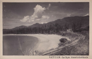
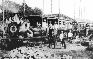
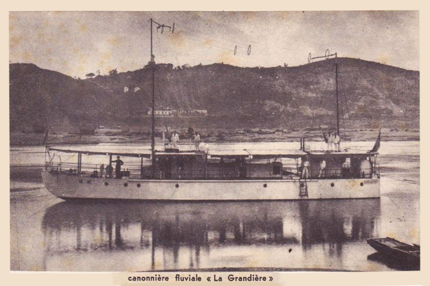
A French gunboat on the Mekong

My mission to identify anchorages on Phu-Quoc was aimed at finding, along the coast of the island, a safe haven for small boats, and, thereby facilitating communications with Ha-Tien, permitting our gunboats to come here in almost any season. Years have passed without a boat from our naval station coming to Phu-Quoc; only at very long intervals could one see a small inspection craft from Ha-Tien, improperly equipped for a trip of several days.

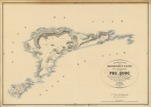
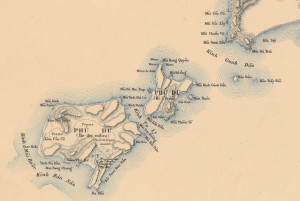
Cochinchine française, Arrondissement d’Ha-Tien, Plan topographique de l’ile de Phu-Quoc, 1897

However, the inlet which separates Phu-Quoc from the coast of Cochinchina is sheltered from both the northeast monsoon and the southwest monsoon; the sea is often calm, and the distance is only 35 miles.

We can, in most seasons, count on at least a few hours of good weather to make the journey. When, through the deepening of Vinh-Te canal, our naval vessels will be able to access Ha-Tien all year long, travel to Phu-Quoc will become very easy – once we know where to find safe anchorage.

Accompanied by Lieutenant Pitout, I left Ha-Tien on 16 December in a small inspection craft. The breeze coming from the northeast brought us to the southern tip of Phu-Quoc. I decided to start our tour of the island there; that would be our first mooring, then we would head north along the west coast, sheltered from the monsoon, and finally, with a favourable wind, we would descend quickly from north to south along the east coast, which is constantly battered by the sea and offers no shelter.

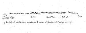
Renaud’s sketch of the Appearance of the east coast of Phu-Quoc, 6 miles off the coast in the east, abeam from Ham-Ninh

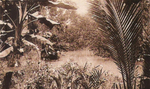
Even before arriving in Phu-Quoc, one may recognise that this is a mountainous land. From a distance, its great plateaux with sharp precipices, seemingly an extension of the great Elephant Chain, contrast strongly with the granite peaks found in Cochinchina and all the southern islands of the Gulf of Siam. Their unique appearance suggests that we are looking at sandstone mountains with porphyritic rocks, terrain made up of sandy deposits which constitute the intermediate stage in geology which evolved from primitive land of purely igneous formation (see View 1: Appearance of the east coast of Phu-Quoc, 6 miles off the coast in the east, abeam from Ham-Ninh).

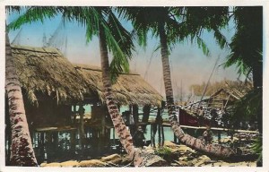
Bay-Cay-Dua – At nine o’clock, we anchored in the southern bay of Phu-Quoc; the sea was rough, but we found excellent shelter there.

The next day, the 17th, the northeast monsoon blew a real gale; despite the very heavy seas offshore, our bay remained perfectly sheltered and calm. The south coast of Phu-Quoc is completely deserted.

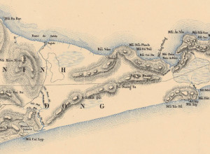
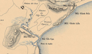
The southern tip of Phú Quốc, showing the Coconut Tree Bay, Plan topographique de l’ile de Phu-Quoc, 1897

The bay called Coconut Tree Bay has existed only for a few years. The great peninsula which encloses the bay on the eastern side (which I named Monkey Peninsula) is high, entirely wooded, and with a rounded tip, the rocky coasts leaving room for only two small beaches bordered by filao (Casuarina equisetifolia) trees. It is connected to the island only by a very narrow and very low strip of land, which, however, is not submerged at high tide, as shown on the English map.

The two islands of the west are entirely rocky, inaccessible, long and narrow, forming a good shelter against the winds and the southwest sea, which is already broken by the group of large southern islands.
The bay has a white sandy beach and there is also a small stream, where one may find fresh water.

It was on its shores that, in 1873, the plantation of M. Desgrois, then Attorney General in Saigon, was established; but today there is nothing left of what he called the “plantation Saint-Louis.” He had cleared the land and planted some coffee, of which I could find no trace.
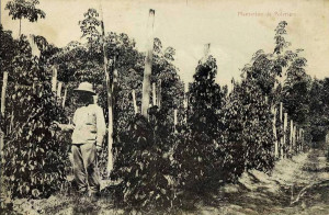
A coffee plantation

The soil is sandy, forming, to a distance of one kilometre, a plain which rises gradually to the wooded hills running from east to west, crossing the island, connecting with the two southwestern and southeastern peninsulas and rounding into a great semicircle which completely shelters the bay from the winds emanating from the north.

The seabed is very regular; a 10m deep seabed runs parallel to the beach over a distance of half a mile; during the northeast monsoon, the sea is very calm, and there are anchorages everywhere; just a short distance from the coast, one may find a seabed of mud mixed with sand, which forms a good anchor-holding bottom.

In the interior, the low mass of the southern hills leads to a square summit on the west coast, while on the east coast there is a pointed summit, near Dam. A large plain divides the island into two parts, just south of Ham-Ninh. There, one may find a small stream, the mouth of which is called Cua-Lap, which alone interrupts the continuity of the beach between the square summit and the island’s capital of Duong-Dong. This is just an insignificant stream, and one can only travel along it in a small boat; even then, one is forced to stop a few kilometres from its mouth.

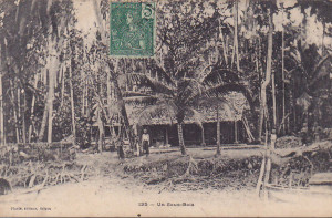
A Vietnamese house in the forest

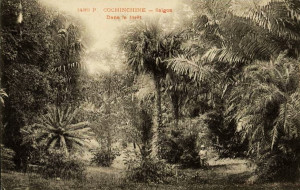
The plains and hills inland are entirely wooded. Vegetation near the coast, constantly battered by the Gulf of Siam’s very fresh southwest monsoon, does not acquire its full development.

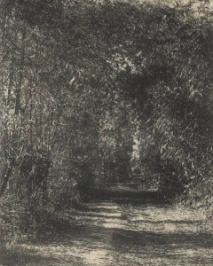
However, it becomes more beautiful as one penetrates deeper into the interior; sandy soil also becomes less pure. One only reaches the great forest after travelling some distance inland, as the hills begin to come into view. This part of the island is represented in the View No 2, taken within a mile of the mouth of the Cua-Lap.

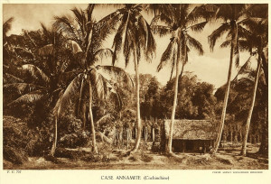
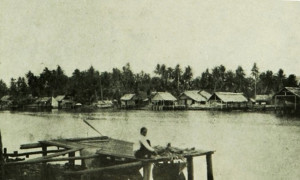
Duong-Dong – At four o’clock we anchored in front of Duong-Dong, the capital of the island and the first inhabited place we had encountered on the coast. Duong-Dong is marked by a large black sandstone rock, visible from some distance, which lies at the entrance to the river and contrasts strongly with the white beach and the great cluster of filao trees. Viewed as a whole, the village offers a most pleasant appearance, with its houses hidden under coconut trees, and its fortress surrounded by a high fence. In front of it, next to the sea, is the former house of the administrator; at the entrance of the river, the large black rock is topped by a shrine, to which sailors and fishermen come, bringing offerings.

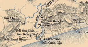
The area around the island’s capital, Đương Đông, Plan topographique de l’ile de Phu-Quoc, 1897

The river of transparent water which runs through Duong-Dong is lined with several rows of tall filao trees; behind it are three or four layers of wooded hills, leading to the highlands of the east coast (see View of Duong-Dong, taken 600m offshore, abeam from the Inspection).

The population of Duong-Dong numbers around 600 inhabitants; inside the fort resides the Huyen, who is the head of the island and has 17 militiamen under his command. The previous Inspection, built from wood, is in very poor condition; placed beside the beach, it can be a pleasant place to stay during the northeast monsoon when the sea is calm; but during the southwest monsoon it is not habitable. The Annamites never build next to the beach; all of their houses are on the river, sheltered by the first sandbank. I think that if one would like to restore the old Inspection, it would be appropriate to choose a new location.

The Annamite huts of the village, numbering around one hundred, are made from tree bark and do not have the miserable appearance of most of those of Cochinchina; the people here are all rich.

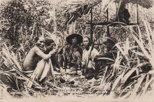
Fish sauce fermenting in tanks

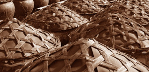
The greatest resource of the country is nuoc mam or fish sauce; it is made with a small green and white fish, a few centimetres long, and nowhere is it encountered in such abundance as on Phu-Quoc. The nuoc mam of Phu-Quoc has a great reputation; it appears on the table of the King of Annam and in all the rich yamens of Canton. One makes nuoc mam by stacking the fish with salt in large tanks; after a few days, this produces a fermentation which results in a yellowish cloudy liquor, with a very strong odour, which is stored away from air and light; after 15 days, one gets the clear nuoc mam, almost odourless, which is sold in bottles. It can be stored indefinitely and does not have the repulsive smell of the fish sauce which is made in Cochinchina, notably in Phuoc-Tinh near Baria.

Fishing takes place during the northeast monsoon season; each house has a large shed where the tanks are stored; the finished product is sent to Saigon via Ha-Tien. Last year, the fish were abundant; this year, the fishing is not so good, so that the nuoc mam is more expensive. I was assured that the Annamites make, with nuoc mam, an income of around 3,000 to 4,000 ligatures each year. In 1878, the amount of nuoc mam exported to Saigon via Ha-Tien was 4,280 piculs.

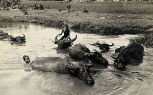
Buffalos in the river

The people here do not cultivate the land and do not even have the idea of clearing space for a little garden; opposite the village is a small swamp where about 70-80 ligatures of rice are harvested each year.

Besides the nuoc mam, they also sell salted fish and turtles caught on the coast; a beautiful Hawksbill turtle may be sold for up to 40 dollars.

They also harvest resins and oils from trees in the forests.

Finally, they hunt; deer and wild boar may be found here in great abundance. Wild buffalo, from which the skin and horns are sold, abound here. In the great plain behind Phu-Quoc, the ground is literally ploughed up by their hooves. The wild buffalo of Phu-Quoc have a great reputation for wickedness; yet the danger is greatly exaggerated. At night, they travel in bands and come close to villages, where dogs utter terrible barks; they ravage all the crops, and this is one of the reasons invoked by the Annamites not to cultivate gardens. But by day, they retreat deep into the forests and are very difficult to find. Most live in herds and are not malicious; the only truly dangerous ones are the lone old buffalo; those have even been known to charge Annamites without being threatened, but happily they are few and far between.

South-central Phú Quốc, showing the fertile plain east of Dương Đông and the southeast coastal region where the Bay-Viam and Dam plantations were situated, Plan topographique de l’ile de Phu-Quoc, 1897

The danger of snakes on Phu-Quoc has also been greatly exaggerated; I was told that the Annamites dare not keep hunting dogs, because they would all be eaten by boas; in fact, this is not true, and accidents are rare. Caimans, which abound in some rivers, are much more dangerous for dogs.

The land which stretches behind Duong-Dong is a large sandy plain where the forest has been cleared; amid the bushes, and in clearings created during various ages, run many hunting trails traced by the Annamites; the over-permeable soil, formed from pure sand near the seashore, becomes very fertile in the interior, especially in the valley of the Duong-Dong river, where gardens are grown. Surrounded by high fences and each occupying an area of several hectares, these are maintained almost exclusively by Chinese and supply Duong-Dong with all of its fruit and vegetables. This is the richest area that I encountered on the island.

The river which runs into the sea at Duong-Dong is the most significant river on the island. The plan of the entry into this river was drawn up in 1874 by M. Bain de la Coquerie; it is exact in its essential parts. The narrowness of the river, and particularly the sharp bend which it forms around the sandy promontory in front of the fort, make entry very difficult.

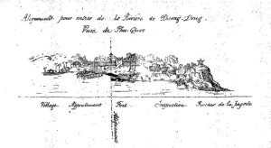
Renaud’s “first alignment” for entering the Đương Đông river

The outer channel runs first between a large bank on the west side, which extends underwater, and a promontory covered with large filao trees on the east side, then between clusters of rocks which form a line parallel to it and lead up to the large black rock near the Inspection.

I determined the alignment to follow in order to hold to the middle of the channel, which, between the bank and rocks, measures no more than 50m. It runs from the flagstaff of the fort to the extremity of the rocks at the end of the beach. One must follow this alignment to its meeting with the second alignment, which runs from the end of the pier to a large isolated filao tree in the interior; it is necessary to pass the sandy point to reach the pier. I give in my first diagram the views I took of these two alignments.

The river is so narrow that, once you have entered, it is impossible to avoid the tide. Fortunately, the current is very weak, a few tenths of a knot at its maximum speed, and the only way to operate is to do all necessary manoeuvres while being moored.

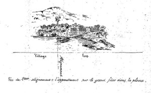
Renaud’s “second alignment” for entering the Đương Đông river

I believe that, in order to choose the best position, one should first moor the boat near the pier. On the west bank, there is a big strong tree, to which a line from the stern of the boat should be attached. That line will run close to the pier on the west side. Meanwhile, the bow of the boat should be moored by a rope to one of the coconut trees or small jetties of the village on the east bank.

To get out of the river, the best way is to send a rope to a stake placed on the tongue of sand abeam from the boat and then to haul on the stake, turning the boat while the stern remains against the pier. The width of the river between the pier and the tongue of sand is around 55m, and the sandbank is very steep.

When penetrating deeper along the river, one must moor the gunboat to the large filao trees which may be found on the second bend; indeed, the only way to forestall free movement on the water here is to attach mooring ropes from both aft and stern to the filao trees. In this operation, the first bend is too abrupt to pass directly, so in order to pass it, you must also haul on ropes fixed ashore.

The estuary at Dương Đông (A Nadal)

These are the two best points where a boat may find shelter on the Duong-Dong river; the first sand dune, the big rock and the trees all offer sufficient shelter against the offshore wind. However, if, in theory, this is possible, in practice it is very difficult; space is so limited that the manoeuvre must be made with extreme precision, for to succeed, one cannot deviate in any given alignment or arrive at a jetty at speed. The captain of a boat, before engaging the channel, must first drop anchor close to the sandbank and go to check out the estuary and the alignments and points where the boat needs to moor. In following the first alignment, one must take great care not to pass its intersection with the second: otherwise one could easily be thrown onto the rocks at the entrance to the river.

In summary, I think that the entry manoeuvre is possible, but extremely difficult; in any case, it should only be attempted in calm weather. The operation would be facilitated if we extended the pier transversely along the red line that I marked on my diagram.

From Duong-Dong to Ham-Ninh and Bay-Viam – The next day, 22 December, we walked from Duong-Dong to Bay-Viam, crossing the island by its only road, which runs between Duong-Dong and Ham-Ninh. The road is well maintained, and one could easily pass along it on horseback or in a carriage – if there were any horses or carriages on Phu-Quoc! The distance is about 25km. Leaving the fort, the road skirts the village of Duong-Dong and follows the river valley, where we encountered Chinese gardens, several rice paddies, and later the remains of an old pepper plantation which had been abandoned for 20 years.

Deep in the forest

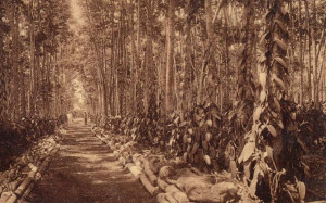
It was only after three quarters of an hour walking along this road that we finally entered the vast forest. It extends over a sandstone outcrop which, here as in all other countries, supports the development of trees; the richness of the forest floor in Phu-Quoc impresses all those who have visited the island.

The trees grow straight and tall here, slender without branches on the lower parts, their upward growth in the early years being exaggerated at the expense of their width. Here, one encounters every species of tree from our provinces of Cochinchina and Cambodia, all reaching their maximum development. The gomme-gutte (gambodge) tree is here in abundance; we shall see later what it can bring. I saw yao trees almost 100 feet high.

This beautiful forest covers almost the whole island; I also found here sandstone rocks, sometimes very ferruginous.

Half an hour before arriving in Ham-Ninh, we left the great woods to enter a field of small clearings and thickets. The soil near the east coast seems less rich; the plain is less expansive, the mountains leave little land between the coast and their very steep slopes. We encountered many tram trees [a variety of agarwood] of a very inferior oil quality, and the prairies were covered with horsetails and other plants of the equisetum family, which indicated poor soil.

Another Vietnamese house in the forest

The village of Ham-Ninh is located a few hundred metres from the coast; it consists of about 20 houses, each surrounded by a small garden cultivated with care. There must be around 100 inhabitants here; the small stream which runs through the village is only a few metres wide.

The main industry of Ham-Ninh is producing mam-rouc, a kind of nuoc-mam made with shrimp, highly esteemed by the Siamese, which is exported almost entirely to Bangkok or Kampot.

From Ham-Ninh to Bay-Viam, we follow the beach; the distance is about 7km. I find all along the coast traces of erosion; at every step, trees lie on the beach, uprooted, their trunks already far from the current high water mark. Since the start of the northeast monsoon this year, the sea has certainly advanced at least 3 or 4m.

The bay at Bay-Viam is only a temporary harbour with no shelter; one would need to anchor off the coast, because coral reefs and sandbanks obstruct the whole. It is bordered by a huge beach lined with filao trees.

It was at Bay-Viam that Messrs Girard and Coutel established their plantation, right by the sea, at the foot of the wooded hills which surround the bay. On the shore are a few workers’ houses and a small jetty just across the road from these dwellings.

A vanilla plantation

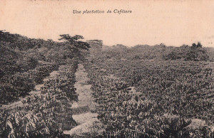
The plantation of M. Girard was the first attempt at crop-growing on a large scale in Phu-Quoc; as such, it is very interesting to visit; unfortunately, it is only 4 or 5 years old, and has thus not yet reached its full development. Only one part of the plantation is situated in Bay-Viam – the rest is located in Dam, a few kilometres further south, near the bay of the same name; the latter has roughly the same soil and topography. Messrs Girard and Coutel have planted a total of 55,000 feet of coffee trees – 35,000 in Bay-Viam and 20,000 in Dam. As yet, they are far from being in full fruit; most, it is true, have been planted for only two or three years and the harvest this year yielded only 250kg of coffee. The shrubs are planted every two metres, half sheltered from the sun under some large trees. At first glance, they seem healthy; however, unfortunately I found the presence of the “little worm” which wreaks havoc on so many of the coffee trees of Cochinchina – this is the pestilence which destroyed the plantation at Bien-Hoa, and for which we have not yet found a cure.

Next to the coffee trees sprout vanilla plants. These have still not produced anything, but they have a very beautiful appearance; At first they were given defective supports made from dead wood, onto which the stem of the vanilla stuck and was almost burned where it made contact with it. The current Annamite overseer has replaced them with small shrubs from Cambodia, planted in two rows, and whose branches formed a cradle to permit the vanilla flower to be fertilised directly.

A pepper plantation

Next to the vanilla plants, 300 pepper plants also seem healthy, but are still too young to give significant results.

Finally, over a period of five years, Messrs Girard and Coutel planted 17,000 coconut trees, but many of these died, so that now there are just 5,000 to 6,000. It is hoped that, in seven or eight years, these will have achieved their full development.

Last year, they made a test harvest of gomme-gutte or gamboge. The forests of Phu-Quoc are rich in gamboge trees, especially in the regions of Bay-Viam, Dam and also Cua-Kan on the west coast. They must be grown naturally and harvested when they reach maturity. The best size for gamboge shrubs is around 7-10cm. Harvesting is done in February; one makes two spiral grooves on the trunk which meet at the lower end, so that the sap may be channeled into a small bamboo pipe. Each tree can produce annually an average of 100gms; last year, the Girard and Coutel plantation only harvested 7kg, but this is a crop that could easily be grown in large proportions.

In summary, the plantation of Messrs Girard and Coutel has still produced little or nothing; but to be fair, it has not yet acquired its full development. It is neat and well maintained, and it is, in any case, a company which sees great merit in experimenting with new crops.

I will not comment on the considerations which led the growers to choose the locations of Bay-Viam and Dam. The mountains along the coast completely shelter the fields from the breeze for 7 or 8 months, and the climate is very unhealthy, even for the Annamites. The shore, lined with coral and sandbanks, is very difficult to access; there are no communications, no resources, and finally, perhaps the most important consideration,

Plantation labourers taking a break from their back-breaking work

I think that the soil is less fertile than in some other parts of the island, especially the river valley east of Duong-Dong, where the Chinese gardens may be found. That, in my opinion, is the location where a plantation should have been established; it enjoys the most favourable conditions, including climate, means of communication and richness of soil.

Personnel employed in the Girard and Coutel plantation total 32 labourers, who clear, irrigate, weed and maintain the plantation. They are paid 1 franc per day, plus a ration of half a picul of rice each month. While the Annamite overseer is very smart, and, having visited Bourbon, familiar with the French style of plantation, it is nonetheless regrettable that a property of this size is not monitored by a European, or at least inspected from time to time.

The only inhabitants of Bay-Viam are the plantation workers; in Dam, there is a village of about 150 inhabitants, where, as in Duong-Dong, they make nuoc mam. I had hoped to find a good anchorage there, seeing the well-closed bay surrounded by high peaks, but once again, coral reefs hardly permit a boat to enter, and there is no fresh water there.

On this part of the coast, I found many sandstone rocks, and, incidentally, porphyry and gneiss; in times gone by, they exploited jet mines here, which are now abandoned.

A path through the forest

On my return to Ham-Ninh, I did not take the same road. Instead, I followed a small path through the interior. This trail and the road from Ham-Ninh to Duong-Dong are the only roads which exist on the island of Phu-Quoc. One passes through clearings and forests of tram trees; the soil is formed of white sand; it is indeed one of the worst terrains on Phu-Quoc; trams and horsetails grow here at will.

Bounla – After returning to Duong-Dong, we got up soon after midnight next day to head further north. We followed the coast, cooled by a light breeze from the northeast; not until noon did we arrive in Bounla. There lie the ancient construction sites of M. François, who tried, three or four years ago, to exploit the wood of Phu-Quoc. Visiting the remains of his plantation, we found no more than two or three huts for storing large pieces of wood, abandoned and rotting; they were located about 40m from the coast, near a small stream where fresh water may be had. The rafts which he used initially to transport his wood were destroyed by the sea; later, the junks he hired capsized, being too heavily loaded. In the end, he abandoned everything, and his former workshops are now in ruins. It is said that, all told, the unfortunate M François lost around 2,000 piastres.

The problem of how to exploit the forests of Phu-Quoc could be solved by building a network of roads to transport heavy pieces of wood to the coast; and, if the operation is carried out on a large scale, it would also be advantageous to have in Ha-Tien a tugboat which would come in good weather, on one or the other side of the island according to the monsoon, to haul rafts laden with wood from Phu-Quoc to Ha-Tien and Chau-Doc.

Cua-Kan [Cửa Cạn] – From Bounla, we continued our journey north by sea to Cua-Kan, where we anchored at about 3pm. A river opens at the north end of the great beach, 30km in length, which runs all the way from the square summit; at high tide there is no more than a metre of water above the breakwater.

The area around Cua-Kan (Cửa Cạn), Plan topographique de l’ile de Phu-Quoc, 1897

The entrance to the river is very narrow, but it immediately widens into a deep basin. From there, a small waterway heads a few kilometers towards the north, while the main river runs due west. It is around 80m wide, and shallow. Around 1.5kms from its mouth, one arrives at the village of Cua-Kan; It has around 150 inhabitants, all manufacturers of nuoc mam and all rich. There is no trace of agriculture, apart from some poor gardens and the few coconut trees which shelter their huts. We noticed in Cua-Kan a special type of fishing boat, very well built and very elegant. As in Duong-Dong, the people here hunt buffalo and deer with packs of dogs.

We continued up the river as far as the point where it is reduced to a trickle; thereafter, trees crisscross the waterway and there is no way to pass. This small brook finds its source in the Saint-Byoot massif, and thus crosses almost the entire island.

All of the rivers on Phu-Quoc are alike: at their mouths, they have barriers that do not even permit junks to enter; their waters are transparent, with almost imperceptible currents; and they are initially wide and deep enough for navigation, but after a few kiometres they become tiny streams which cannot even be used to transport floating timber. So we must rely on the development of roads to exploit the forests.

All of the rivers of Phú Quốc are reduced to insignificant streams just a few kilometres from their mouths

Cua-Kan seems to be established on one of the worst terrains of Phu-Quoc, whose ground comprises hard ferruginous sandstone; trees grow poorly here; one encounters many trams and shrubs, at least in the part of the river on which I travelled.

Yet, as one advances, the ground seems to rise above the sandstone layer and the trees become larger.

Around 2km east of Cua-Kan, the river makes a very pronounced bend and heads southwest. Then, around 500-600m further on, it veers back towards the south-south-east, then east again.

By the time it reaches its last bend, about 4-5km from its mouth, it is no more than an insignificant stream.

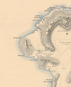
The Ile de l’Eau (Water Island) and Ile de Milieu (Middle Island) – On the morning of 25 December, we set sail to visit the islands north of Phu-Quoc, having discovered that the entire northern part of the island is now deserted, and the ancient villages of Vuong-Bao et de Bay-Doi, though still on the map, no longer exist.

The small islands of Grands-Arbres, Clump and Chenal may be seen from afar; these should not be confused with the flat rock which sits a mile off the north end of the island, poorly visible, which it is prudent to watch out for. This part of Phu-Quoc, between Cua-Kan and the Ile de l’Eau, is where the local people fish for Hawksbill turtles. The breeze is very light, and some time later we arrive at the Ile de l’Eau. Several huts giving shelter to around 20 Annamite fishermen are located near the northeastern bay. This bay is very dangerous, full of rocks and corals, and there is no anchorage.

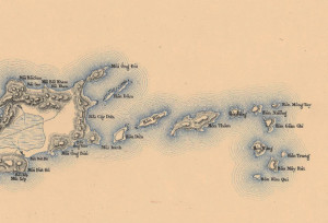
The Ile de l’Eau (Water Island) and Ile de Milieu (Middle Island), Plan topographique de l’ile de Phu-Quoc, 1897

Water Island is so-called because of the fresh water wells which may be found near the fishermen’s huts; their existence is explained by the fact that the lower layer is made from the same impermeable ferrous sandstone that I had seen in Cua-Kan, while the upper layer and the mountain on the island are made from very permeable sandstone and sand. I found pumice stone here; there are also some jet mines. As in Ham-Ninh, the inhabitants manufacture mam-rouc.

Beyond the Ile de l’Eau is the Ile de Milieu (Middle Island), which also belongs to us, and contains a few fishermen’s huts.

It’s at its northern end that the island of Phu-Quoc offers its most picturesque appearance; all of its wooded summits take many varied forms between northwestern tip of the island and the Kwala Cape, dominated by the highlands of the east, and creating a belt around the two large bays of Bay-Diem and Retram. From the left side of Cape Kwala, one may see as far as the mountains of Ha-Tien, the Kep promontory and the hills of Kampot.

To the east, the great Elephant Chain is entirely visible, while looking north, one can see the entire coast as far as the great estuary of Kompong-Som.

Bay-Diem – During the night, the breeze from the northeast lifted. We left our anchorage at Water Island and sailed to Bay-Diem, which sits in a bay, with an entrance to a river which is blocked by sand like all previous; near the mouth of that river, we found traces of an ancient village. We travelled up river as far as possible, but after just 3km it too became little more than a stream; it was full of fish; the soil seemed excellent and the trees healthy.

The northern coast of Phú Quốc, showing the Kwala Cape (Núi Chão), Plan topographique de l’ile de Phu-Quoc, 1897

The harbour of Bay-Diem, sheltered from the winds of the south, east and west, remains open to the north wind, having before it in that direction a body of water of over 20 miles, and when the northeast wind blows along the entire Elephant Chain, the sea here can be very rough.

Retram – Later the same day, we headed for Retram, located close to Bay-Diem on the other side of the Cape Kwala summit. The plan of the bay and the river drawn in 1868 by M Béhic is inexact. Firstly, he drew the river roughly twice the scale of the bay; there is little more to trust from him when one reaches the second bend, downstream from Retram. Furthermore the jet mine, which he claims is located close to the village and the river, no longer functions. To get there from Retram involves a further half-hour walk.

Retram harbour is even less sheltered from the winds of the north than that of Bay-Diem; filled with rocks and corals, it is, because of the north wind, a very bad anchorage. The Retram river is also blocked and is as narrow as that at Bay-Diem; at a distance of 1.5 miles from its mouth, we encountered traces of an old village.

Years ago, a mining operation here was granted to a Frenchman, who lost money and then abandoned it; the Annamites no longer have the right to mine for jet, and the village has disappeared.

As we reach the village, the portion of the river navigable for boats comes to an end. From there, we walk along a small path which leads to the old mine shafts, located 3km southwest of Retram. There we find four mines, flooded and abandoned; from one of them they removed anthracite. The rock in which the jet lode lies is sandstone, and right next to it I found porphyry. Jet appears in several places in Phu-Quoc; we have mined it in Bay-Doc, in Bay-Viam, in Duong-Dong, and on the Ile de l’Eau. It is highly valued by the Annamites, who use it to make bracelets and necklaces; one small jet bracelet costs 3 or 4 piastres.

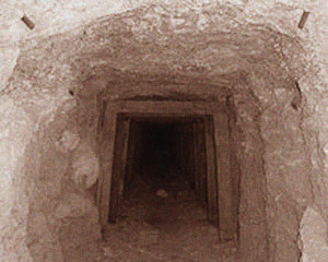
An abandoned mineshaft

I brought back many samples of jet, still attached to its rock. However, I had great difficulty accessing the mineshafts, which were already overgrown with bushes and shrubs; in a few more years they will be completely inaccessible and forgotten.

Bay-Doc – We left Retram the next morning; the breeze was so light that we took 24 hours to round Cape Kwala, taking care to keep well clear of the rocks which line the northern coast of the island. South of Mount Kwala is a small stream of little importance.

To acess Bay-Doc from the sea, one must first get round the great sandbank which stretches nearly three nautical miles east from the village; only after having passed it can one turn back and enter the narrow channel which leads to the village. Even then, in a small vessel with a draft of no more than 1.5m, we had to anchor after no more than a mile.

Bay-Doc is surely the poorest village of Phu-Quoc; it sits beside the beach and is recognisable from afar by its many clumps of coconut palms. It is populated by around 100 people who produce neither nuoc-mam nor mam-ruoc. They make a living only from fishing, and the fish they catch – which includes swordfish and sharks – is mostly salted.

We arrived just as they were bringing ashore a huge swordfish, and they offered me the saw, which measured more than 1m long! The flesh of these big fish is cut into strips and dried in the sun on the wooden frames which line the beach; saws and fins are carefully stored and sold in the market at Duong-Dong.

A fishing village on Phú Quốc

Behind Bay-Doc are the highest mountains of the island, part of an entire chain which runs parallel to the coast from Mount Kwala to Ham-Ninh. The small plain that stretches west of Bay-Doc looks excellent for agriculture; but local people have not cleared even the slightest bit; they still claim that wild buffalo and deer ravage all plantations.

On the same day we left for Ham-Ninh, which we had already visited while crossing the island from Duong-Dong.

We then spent a very bad night; in the evening, the wind rose, and although we were anchored nearly a mile from the coast, the breakers were very close behind us. Fortunately, our anchors held fast, and by morning the wind had shifted to the southeast. One should abstain from anchoring for the night anywhere along the east coast of Phu-Quoc during the northeast monsoon; there is no shelter and it is dotted with dangerous reefs and rocks.

We passed again before Bay-Viam and Dam, unable to land because the sea was too rough; very soon, we found ourselves back at the southeast peninsula, our starting point. From there, we headed back to Ha-Tien, pushed by a gentle breeze from the southeast, and arriving on the morning of 31 December.

In summary, Phu-Quoc is a large, uncultivated island, apart from a few hectares of coffee plantation and the small gardens of Duong-Dong, covered throughout its whole extent by beautiful jungle which grows on a forest floor of exceptional richness and is exploitable, provided we build roads. Although its size is larger than that of Martinique, it has a total population of just one thousand inhabitants, divided amongst five villages. I did not see any Cambodians; in Duong-Dong there were a dozen Chinese involved in opium farming and garden culture. The Annamites are gentle, intelligent, very obliging, and we liked them very much.

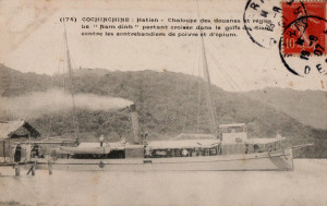
The Customs and Excise vessel “Nam-Dinh” leaving Hà Tiên to patrol the Gulf of Siam

The people of Phu-Quoc gained a lot when we arrived in the western provinces of Cochinchina; previously they had faced the problems still experienced today by the populations along the coast of Annam, which are constantly subjected to exactions by pirates. Before we came, no junk was safe when its left Duong-Dong to go to Ha-Tien. Thanks to increased security, I was told that in the last five years the export of nuoc mam from Duong-Dong had increased tenfold, and all the producers had become rich.

However the population of this island is not increasing, since there are no newcomers; it seems that for most of the Annamites in Cochinchina, Phu-Quoc is still considered a land of exile, devoid of rice fields and fertile ground, a place where no-one would choose to go at any price.

In geological terms, the island of Phu-Quoc belongs to the class of intermediate terrain; its principal formation is sandstone, and incidentally there are also micaschistes, gneiss, porphyrys, variolites, sandy deposits, etc. Many of its rocks are ferruginous; I saw some traces of lead ore and copper, though in inappreciable quantities.

In some places, such as in the south, along the entire coastline behind Ham-Ninh in the east, and at the entry to Cua-Kan in the northwest, the terrain is made from porous sand, consisting of almost pure quartz or silica. In others, like the valleys east of Duong-Dong and near Bay-Diem, the soil looks excellent and very good for all kinds of crops.

Renaud’s sketch of the Coconut Tree Bay

During the northeast monsoon, the sea is calm on the west coast and one can anchor almost anywhere, at a small distance from land, but during the southwest monsoon, the sea can become very rough. Safe shelter cannot be guaranteed until the monsoon is well established and there is no further need to fear a change of wind.

The bay at Bay-Diem, perfectly sheltered from the winds of the south, is open to the winds from the north.

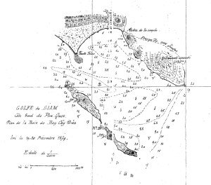
Cay-Dua Bay, of which I drew a map, seems best for mooring a small boat; it is completely sheltered from all winds, except for that from the southeast; and when the wind turns in that direction, one has the advantage of not being cornered at the bottom of the bay; the pass near the tip of the filao promontory permits us to exit the bay and seek shelter behind the two small islands of the west, which are situated behind the larger islands further south.

Practically the only river in Phu-Quoc which can be entered by a small boat is that of Duong-Dong; but access is difficult, and the manoeuvre demands such precision that it may only be attempted in very good weather and with a perfect knowledge of the area.

In these circumstances, it is certain that, if transportation was improved and the island became more heavily populated, Phu-Quoc would be covered with plantations. However, if roads are built to exploit its forests, it will also be necessary to create a proper port to which all of the island’s roads can lead. At present, there is not one inhabited point on the island to which a boat with a draft of 1.50m can come to shelter in any season.

Saigon, 16 January 1880
J. RENAUD
Engineer, Hydrographer of the Navy
Published in Excursions et reconnaissances, 1880

Tim Doling is the author of the guidebooks Exploring Huế (2018), Exploring Saigon-Chợ Lớn – Vanishing heritage of Hồ Chí Minh City (2019) and Exploring Quảng Nam (2020), published by Nhà Xuất Bản Thế Giới, Hà Nội

A full index of all Tim’s blog articles since November 2013 is now available here.

Join the Facebook group pages Saigon-Chợ Lớn Then & Now to see historic photographs juxtaposed with new ones taken in the same locations, and Đài Quan sát Di sản Sài Gòn – Saigon Heritage Observatory for up-to-date information on conservation issues in Saigon and Chợ Lớn.

Notice on Historic Tombs in the Province of Gia-Dinh, 1924

Around Saigon – the Tomb of a Mandarin

A translation of the Report of 21 June 1924 to the Administrator of Gia-Dinh regarding the ancient tombs in the province, found in the National Archives.

I. The Tomb of Le-Van-Duyet

“Tombeau du maréchal Lê-Van-Duyêt, vice-roi de la Basse-Cochinchine, premier mandarin de l’Empire (1763-1832)” 1921-1935

Le-Van-Duyet, better known to Europeans by the name “Great Eunuch,” was appointed by Minh-Mang in 1822 as Viceroy in charge of Cochinchina. The high position he occupied, and the great prestige which surrounded him, were due as much to memory of the glorious services he had rendered to Gia-Long during the wars against the Tay-Son, as to his deep sense of justice.

Duyet died in 1832, and today his tomb is located right opposite the Inspection of Gia-Dinh, on the land where he had his country house. His memory is greatly venerated; he was classed among the most powerful minds in the indigenous theogony. A pagoda was established next to his tomb, one of the largest ever to have been built, to which devotees come every day to offer sacrifices. It is also here that, in the assembled presence of village notables, and following fixed rites, the most solemn judicial oaths are taken.

This tomb is carefully maintained in its pristine state. The pagoda is currently being restored. This work is being directed with undisputed competence by Mr Diep-Van-Cuong, whose skills will save this monument of pure Annamite style from undergoing a shocking modern restoration.

II. The Tomb of Le-Van-Phong

A Tomb of an Annamite Mandarin

Le-Van-Phong was the brother of Le-Van-Duyet. His tomb is located in the village of Tan-Son-Nhat (canton of Duong-Hoa-Thuong), close to that of the Bishop of Adran.

This tomb is located on the rubber plantation of Mr Cravette. That colon offers free access to the tomb to local people, who are very grateful to him that they are able to celebrate the cult to the memory of the deceased. There is indeed an indigenous association for that purpose.

III. The Tomb of Vo-Thanh

Cochinchina – A Mandarin’s Tomb

Vo-Thanh, valiant Marshal of Gia-Long, has his tomb in the village of Phu-Nhuan (canton of Duong-Hoa-Thuong).

This imposing tomb is surrounded by several pine trees which were planted, it is said, on the orders of Gia-Long. An indigenous association has also been constituted here to observe the cult of his memory.

IV. The Tomb of Vo-Di-Nguy

Saigon – Tomb of a Mandarin

Vo-Di-Nguy was also a companion at arms of Gia-Long. His tomb, like that of Vo-Thanh, is located in the village of Phu-Nhuan (canton of Duong-Hoa-Thuong). It is situated behind a house belonging to Miss Therèse Vidal, and on her property.

Despite the merits of Vo-Di-Nguy, no indigenous group currently exists to honour his memory. The tomb is currently looked after by a few local people from the neighbourhood.

V. The Tomb of Nguyen-Van-Hoc

Souvenir of Cochinchina – Tomb of a Mandarin

Finally, one should note another tomb, located on the grounds of Captain Pham, near the Treasury of Gia-Dinh. Judging by its architecture, its imposing dimensions and its decorative motifs, the tomb must be that of a great dignitary.

After investigations and research by Doc-Phu [Governor] Phat, it seems that the tomb is that of Nguyen-Van-Hoc (?), Marshal of the Vanguard of Gia-Long and novice ordained by the Bishop of Adran.

See also Forgotten Nguyen Dynasty Tombs of Phu Nhuan.

Tim Doling is the author of the guidebook Exploring Saigon-Chợ Lớn – Vanishing heritage of Hồ Chí Minh City (Nhà Xuất Bản Thế Giới, Hà Nội, 2019)

A full index of all Tim’s blog articles since November 2013 is now available here.

Join the Facebook group pages Saigon-Chợ Lớn Then & Now to see historic photographs juxtaposed with new ones taken in the same locations, and Đài Quan sát Di sản Sài Gòn – Saigon Heritage Observatory for up-to-date information on conservation issues in Saigon and Chợ Lớn.

“Cochinchina – Principal Centres of Population” from Notices coloniales, Antwerp World Fair, 1885

Saigon – the Botanical Gardens

Published on 3 June 1885 to coincide with the Antwerp World Fair (2 May-2 November 1885), Notices coloniales, publiées à l’occasion de l’Exposition universelle d’Anvers en 1885 contains the following description of Saigon, Chợ Lớn and other principal centres of population in French Cochinchina.

1. Saïgon

The city of Saigon is enclosed by an irregular trapezoid formed by the Saigon river to the east, the arroyo Chinois [Bến Nghé creek] to the south, the arroyo de l’Avalanche [Thị Nghè creek] to the north and the belt canal (canal de Ceinture) to the west.

The Grand Canal (now Nguyễn Huệ boulevard), pictured in 1882

Our conquest destroyed the old Saigon. The ambitious plan for the new city was more than just a resurrection; to realise this new creation, it was necessary to reduce the size of the plateau which dominated the settlement and to fill marshes which surrounded it, laying streets and building houses on shaky ground. This great work took several years.

The first street we created was the rue Catinat [Đồng Khởi], which was established on the path of an ancient Annamite street leading from the river to the citadel; all other major arteries run parallel to it. To the left of this street is the Grand Canal [Nguyễn Huệ], which permits boats loaded with freight to dock right in front of the main City Market. That market consists of eight large covered halls whose appearance would not look out of place in a large European city; here also, either side of the canal, are the quay Charner and the quay Rigault de Genouilly, which both extend as far as the rue d’Espagne [Lê Thánh Tôn]; and at the top of the canal we planted a lovely square on which a granite monument was erected to the memory of commandant de la Grée, leader of the Mekong expedition.

The City Market pictured in the 1880s before the filling of the Grand Canal

To the right of the rue Catinat is the rue Nationale [Hai Bà Trưng], a pleasant thoroughfare 20m in width, which departs from the Rond-point [Mê Linh square] and runs through the entire length of the city. A square has been built on the Rond-point, where five streets converge.

The boulevard de l’Hôpital [Thái Văn Lung] and the boulevard de la Citadelle [Tôn Đức Thắng] also lead from the quayside, running parallel to the rue Catinat. The boulevard de l’Hôpital stops at the rue d’Espagne, while the boulevard de la Citadelle continues as far as the arroyo de l’Avalanche, whence another avenue leads to Binh-Hoa [later Gia Định], seat of the Inspection of Saigon.

All of these roads run from southeast to northwest. They are intersected perpendicularly by many streets, whose direction is southwest-northeast.

The rue Pellerin (now Pasteur street), pictured in the late 19th century

The most important of these are, starting from the quayside: rue Vannier [Ngô Đức Kế], rue de l’Église [Tôn Thất Thiệp], boulevard Bonard [Lê Lợi], a thoroughfare 50m wide, rue d’Espagne, rue de La Grandière [Lý Tự Trọng], the starting point of the “High Road” to Cholon, rue Tabert [Nguyễn Du], boulevard Norodom [Lê Duẩn], in front of the Palace of the Government, and finally the rue Chasseloup-Laubat [Nguyễn Thị Minh Khai].

Wide streets also lead north from the arroyo Chinois to the Plain of Tombs (plaine des Tombeaux). These are rue Ollivier [Pasteur], rue Pellerin [Pasteur], rue Mac-Mahon [Nam Kỳ Khởi Nghĩa], which at its extremity runs in front of the Palace of the Government, and rue Boresse [Yersin]. In one section of the latter street, which borders the arroyo Chinois, we recently built a petrol store which holds the colony’s entire supply of petrol for two years; behind this store is the city abbatoir.

Saigon – the new quays and docks

All these streets are lined with beautiful sidewalks which cover the vast masonry sewers and have been shaded by the planting of various trees of remarkable vigour, such as tamarind, mango, sao, banana and teak.

The ships of the Messageries maritimes are moored at the entrance of the city, opposite the agent’s headquarters and other important buildings constructed by that company, with the aim of making Saigon the Southeast Asian shipping hub for China and Japan. A beautiful bridge over the arroyo Chinois [Eiffel’s pont des Messageries maritimes or cầu Mống] connects the Messageries to the city, in line with the rue Pellerin.

In front of the Messageries, at the junction of the Saigon river and the arroyo Chinois, are the Signal Mast and the terminus for the steam tramway which runs between Saigon and Cholon. From here, walking north along the quayside, one passes the offices of the Commercial Port Directorate and the Maison Wang-Tai, a massive construction raised by a wealthy Chinese, which now belongs to the Customs and Excise administration.

The main entrance to the Naval Artillery, pictured in the late 19th century

Beyond the entrance to the Grand Canal are many cafés, the headquarters of the Compagnie des Messageries de Cochinchine, the Port of War Directorate, and the shipyards and other facilities of the Marine Artillery. Then on the right, one passes the Naval Wharf and the Admiral’s flagship, the Tilsit, the Indochina station Manning Pool [naval barracks], and finally the Arsenal, which interrupts the flow of quays and continues as far north as the entrance to the arroyo de l’Avalanche.

Between the Signal Mast and the commercial port is the Saigon Railway Station, installed by the company which will soon launch a new rail service between Saigon and My-Tho.

The Saigon Arsenal occupies an area of 22 hectares and measures no less than 950m at its greatest length. This is an establishment of the premier order, which employs more than 600 Chinese and Annamite workers.

The Sainte-Enfance (Holy Childhood) complex, run by the Sisters of Saint-Paul de Chartres, pictured in 1866

Behind the Arsenal are the Botanical Gardens, which house the pavilion of the director, an aviary containing specimens of all the birds of Cochinchina, enclosures housing herds of deer and buffalo, and ponds where many water birds frolic.

In front of the Botanical Gardens, on the rue de Tay-Ninh [Nguyễn Bỉnh Khiêm], is the collège d’Adran. Behind it, with their entrances on the boulevard de la Citadelle, are the Seminary of the Mission, the elaborate façade of which catches the eye, and the Sainte-Enfance [Holy Childhood], a vast and beautiful establishment run by the Sisters of Saint-Paul de Chartres. This is a building of mixed design, ornamented in indigenous style and flanked by a Gothic chapel, whose slender and graceful spire dominates the landscape and may be seen from afar. Opposite the Sainte-Enfance, on the boulevard de la Citadelle, is a convent of European and indigenous Carmelite nuns.

The Citadel is a large earthwork with bastions at each corner, measuring 870m on each side and now intersected by the modern rue Chasseloup-Laubat and boulevard de la Citadelle.

One of the Colonial Infantry Barracks buildings

At the time of our taking Saigon, the Citadel contained huge stores full of rice, which the necessities of war forced us to burn. Within the enclosure, our military engineering corps constructed two magnificent barracks buildings, built of iron and brick and each housing 800 men. These premises, destined for troops of the Naval Infantry, leave nothing to be desired in terms of hygiene and amenities.

The Military [later Grall] Hospital, built to the same architectural design as that of the barracks, with its main entrance on the rue de La Grandière, is a huge facility which consists of a series of large pavilions supported by cast iron frames, connected by covered corridors.

If, on leaving the Citadel, one travels from northeast to southwest, following the rue Chasseloup-Laubat, one passes on the left the old camp des Lettrés [Camp of the literati or Trường Thi, where royal mandarin examinations were once held], which has long served as barracks, and on the right, the Water Tower (Château d’eau) and supply basins. A little further along is the collège Chasseloup-Laubat or École normale supérieure indigene [Lê Quý Đôn High School], a vast building housing 300 students.

The Barbé Pagoda

Just behind it is the Barbé Pagoda [on the site now occupied by the War Remnants’ Museum], named after the captain who was killed there in an Annamite ambush. It was here that Minh Mang, son of Gia Long, was born; and it was Minh-Mang who originally built this pagoda in memory of his birth.

The Park of the Palace of the Government [later the Norodom Palace] and the City Park [Tao Đàn Park], located next to each other, border rue Chasseloup-Laubat opposite the collège Chasseloup-Laubat.

The front façade of the Palace of the Government measures no less than 80m in length. It consists of two pavilions at both ends and a central portion with a dome and covered access ramp. The ground floor, raised over a basement where the kitchens and other service departments are located, contains: on the right, the offices, including the Office of the Governor; on the left, the council meeting room; and in the middle, the dining room, telegraph office and privy council secretariat. Also in the middle is a magnificent vestibule, from which a double width marble staircase leads up to the first floor apartments. Beyond the vestibule is the beautiful and richly decorated events hall (salle des fêtes), which lies perpendicular to the rear façade of the palace and is easily capable of accommodating 800 guests.

The Palace of the Government, soon after its completion in 1872

Leaving the Palace of the Government by the boulevard Norodom, which extends in line with the central axis of the palace, one finds the Bishop’s Palace [on the site now occupied by the Department of Foreign Affairs], the Cathedral and the Cercle des officiers [now occupied by the District 1 People’s Committee], which serves as mess for the marine infantry. The latter is a vast and beautiful property which was established thanks to the solicitude of Admiral-Governor Duperré.

The Cathedral forms the centre of a huge square, in line with the axis of the rue Catinat. The upper part of the rue Catinat, the busiest street in Saigon, along with neighbouring parts of the streets it crosses, are home to all of the main government services. It is at the top end of this street that one may find the Treasury, the Post Office, the Secretariat General, the Land Registry and Mapping Office, the Directorate of the Interior and the City Hall. On the rue de La Grandière are located the Council of War, the Observatory, the Municipal Institution, the Central Telegraph Office, the Police Barracks, the Attorney General’s Office, the Law Courts and, a bit further along, the Prison.

Chettyar (Tamil) money changers in Saigon

The appearance of the streets of Saigon is very lively and curious; here live mixed populations from a range of different civilisations; French and other Europeans, Annamites, Chinese, Malays, Tagals and Indians – most of whom come from Pondicherry and Karaikal on the Coromandel coast – all elbow each other on the streets.

The indigenous population occupies the large suburbs, where it lives at will, building huts along the river, around the markets, or in the middle of small gardens with fruit trees. The Chinese, by preference, live in the lower part of the city, in the commercial areas, and most notably around the main market. The Indians are particularly fond of the areas surrounding the “High Road” to Cholon, the prison and the lower end of the route de Tongkéou [Cách mạng Tháng 8].

European traders are obliged to set up their shops and stores on the quayside or in the surrounding streets. As for government officials, they live mostly on the plateau which overlooks the Saigon river from a height of around 10m, in houses typically built with a front courtyard and a rear garden. The population of Saigon and its suburbs, including soldiers and sailors, government officials and the floating population, may be estimated at 65,000 to 70,000 souls.

Gò Vấp Market in the late 19th century

The areas around Saigon offer the population many beautiful walks and pretty roads which, from 5pm each day, are lined with carriages; this is the time when one can go out without fear of sunstroke. Among the most popular are the roads to Cholon and to the big market at Go-Vap. The neighborhoods en route are populated largely by indigenous people who, having thrown their lot in with us from the beginning and having undergone the vicissitudes of conquest since the evacuation of Tourane, received a concession on the banks of the arroyo de l’Avalanche, between the second and third Avalanche bridges. On the left bank of the arroyo are large and rich villages such as Phu-Hoa and Hiep-Hoa, which provide Saigon with fruits and vegetables.

Leaving the market at Go-Vap and heading south, roughly parallel to the arroyo de l’Avalanche, one follows a magnificent route which, after the first Avalanche bridge, passes the buildings of the Inspection of Binh-Hoa, crosses the road to Hocmon, above the third Avalanche bridge, and continues as far as the route de Tongkéou, passing the tomb of Pigneau de Béhaine, the famous Bishop of Adran, author of the treaty of 1787 between France and Annam and advisor and friend to the Emperor Gia Long.

The Tomb of the Bishop of Adran in 1867

It was to this place, after the pacification of the country, that the bishop of Adran retired and cultivated a garden where he successfully grew the mangosteens he had brought from the islands of the Gulf of Siam. When Pigneau died in 1799, Gia Long gave him a magnificent funeral and ordered the construction, in the middle of Pigneau’s garden, of a funeral monument designed by a French architect in the style of a Cochinchinese pagoda. The tomb has always been respected by the local people, even when Annamite troops occupied the plain of Ky-Hoa in 1861. Later that same year, Admiral Charner declared the tomb to be national heritage.

One returns from the Tomb of the Bishop to Saigon [around 6km] by the route de Tongkéou, which crosses the Belt Canal, the famous lignes de Ky-Hoa, removed after the bloody struggle in 1861, and the arid and dusty Plain of Tombs.

2. Cholon

The city of Cholon is, after Saigon, the most important centre of the colony.

A street in Chợ Lớn

In 1778, a group of Chinese settlers, driven from My-Tho and Bien-Hoa by the invasion of the Tay-Son, came up the Tan-Binh river and founded, on a beautifully selected site, the city to which they gave the name Tai-Ngon. Through the activity and perseverance of the people, this soon became the most important commercial centre of the six provinces of Lower Cochinchina. The Annamites gave it the name Cholon, meaning “Big Market”.

The subsequent ban by the Annamite court on the export of all commodities other than rice, the edict which limited the number of Chinese, and the sumptuary laws which were applied to them, discouraged neither the skill nor the commercial genius of those hardy traders. These vexatious measures did not prevent them from building, at their own expense, stone piers over a length of several kilometres, and making a major contribution towards the upgrading of the canal connecting the Binh-Duong or Vam-Buc-Nghe [Bến Nghé creek] with the Ruot-Ngua which led to Rach-Cat [1819]. The Ruot-Ngua itself had been dug in 1772. At the same time, they completed the work of the arroyo de la Poste [Bảo Định canal], which was dug from 1755. From around 1820, Cholon became the necessary warehouse for all commodities of this rich region.

The Chợ Lớn creek (mislabelled “arroyo Chinois”)

The French occupation initially caused some apprehension among the Chinese merchants of Cholon, but the latter soon realised that it gave them more guarantees for the safety of their business, that they could forever be rid of the abuses of the authorities, and that it promised them the safeguard of equal law for all. Within a few years, the sphere of their transactions had increased tenfold.

Cholon is located 5km from Saigon at the crossroads of an ancient waterway, the Lo-Gom, and the canal which drains it into the arroyo Chinois. The city, regularly embellished and almost entirely rebuilt since our conquest, has quays of several kilometres in length, lined with houses of a beautiful appearance. Many bridges, raised high above the level of the quays to permit the junks and barges free circulation along the canals at any tide, give a unique aspect to this bustling city.

It is through the depot shops of Cholon that pass every year between 4 and 5 million piculs of rice for export; it is here that they are processed and placed in sacks to be taken to Saigon, so that steamships may convey them to China, Japan, Java, Singapore and Manila.

Junks on the arroyo Chinois in Chợ Lớn

Nothing could be more animated than the scenery to be enjoyed from the pont du Jaccaréo [once located near the modern Võ Văn Kiệt-Hải Thượng Lãn Ông junction]. The influx of junks, barges, sampans; in the background, the curtain of greenery around the Cây-Mai pagoda military post; and the docks where we see rushing and fussing labourers, compradors, dealers, store clerks and small merchants; all forming a striking ensemble on which those who still doubt the future of Cochinchina should reflect.

Out in the countryside, the aspect changes: there are retail stores, held by the Chinese if trade is important, and by Annamite women if the business is small. Among the shops belonging to grocers, fancy goods sellers, goldsmiths, restorers, pharmacists, tailors and food merchants, even those of the funeral directors and coffin manufacturers are no less pretty and elegant. Each store has at its door a sign with the merchant’s name in Chinese characters, artistically painted in black, red, blue or gold, according to the fortune or the whim of the master of the establishment.

The Fujianese Theatre in Chợ Lớn

At night, the shops of Cholon stay open. The streets, equipped with lamps which are lit by the municipality, are further illuminated by Chinese lanterns of the most varied shapes and colours, which bear in transparent letters the signs of the merchant. By this time, the hours of labour have ceased, making way for the hours of pleasure; crowds gather at the doors of Chinese theatres, and they all cram inside to attend the endless dramas that are the delight of this race, as eager for amusement as it is active and industrious.

Cholon has a population of at least 40,000 souls. The Chinese here are more numerous; the Annamite population seems to fear being absorbed by them, and tends to live far away from the noisy streets where traffic is too active. The city is regularly intersected by roads, all very neatly kept, and the French police have made the Chinese yield to our habits.

A beautiful market, paved in granite, occupies the centre of the city. One also notes nearby the very fine building constructed for the administrators of Indigenous Affairs.

The Chinese have numerous very curious pagodas, among them that of the warrior gods and the Kouan-Chin-Whay, built by the congregation of Canton to the goddess Apho.

The “Pagoda of the Seven Congregations” in Chợ Lớn

The Chinese population of Cholon is divided between seven congregations which represent the different regions of China from which the Chinese settlers originate, each having its own customs and dialects. However, they agree among themselves, because they have adopted Annamite as their common language, and because ideographic writing is common to both the Annamites and the Chinese. A council of notables, chosen from various nationalities, operates under the direction of the first administrator, dealing with everything related to municipal interests. Cholon has a church, a pawn shop, an important school and a charity office.

There are two roads connecting Saigon with Cholon.

The first is the “Low Road” [route basse] or waterfront road, which follows the arroyo Chinois along its entire length. Half way along is the Choquan Hospital. The Low Road is intersected by several bridges, all in good condition, and offers throughout its course a most picturesque view of the arroyo. At high tide, the latter is covered by an infinity of vessels of all sizes – junks, barges, sampans and even canoes, the occupants of which row with equal quantities of animation and ardour.

The opening of the Saigon-Chợ Lớn “High Road” tramway line in 1881

The second route, the route stratégique, is bordered, as it leaves Saigon, by European gardens, Chinese vegetable gardens and ancient Annamite gardens. It then passes the experimental farm known as the ferme des Mares, where one may see the remains of a royal pagoda, intended to perpetuate the memory of the illustrious men of the country. The route then continues to Cholon via the Plain of Tombs, the burial place of ancient Saigon. This plain is covered, over a distance of several kilometres, with brick or stone mounds; among them are some very remarkable monuments surrounded by high walls.

Cholon is also connected with Saigon by a steam tramway, which follows the old route stratégique and two paved roads.

3. My-Tho

My-Tho, capital of the district of the same name, and former capital of the Annamite province of Dinh-Tuong, is a very important town, both politically and commercially. It is located on the left bank of the northern branch of the Cambodian river, at the junction with the arroyo de la Poste. Formed from the two villages of Dieu-Hô and Dinh-Tao, My-Tho is located around 23 nautical miles by boat and 90km by land from Saigon, to which it will soon be connected by a railway line.

Mỹ Tho – boulevard Bourdais and the Inspection

My-Tho is the seat of an administrator of Indigenous Affairs and also has a courthouse. Its large Annamite citadel was transformed into a military barracks in 1877. Among the straw huts which line the quayside, one may also see many brick houses with tiled roofs.

The town also boasts a beautiful Catholic church, a first class medical clinic, a post and telegraph office, a treasury, a college, and a hospital for indigenous people. My-Tho has around 6,000 inhabitants.

4. Vinh-Long

Vinh-Long is the capital of the former province of the same name; the Annamites call it the “Garden of Cochinchina.” Vinh-Long is situated 26 nautical miles from My-Tho and occupies the angle formed by the Cochien and the Long-Ho, thus controlling the four arms of the Cambodian river.

Vĩnh Long – the quays

It is the place of residence of an administrator and the seat of a court; it also has a huge market and its port is frequented by many Annamite boats.

The city has a citadel, a military clinic, a post and telegraph office, a treasury and several important schools. Vinh-Long has around 5,000 inhabitants.

5. Chaudoc

Chaudoc is the capital of the district of the same name; it is the capital of the former Annamite province of An-Giang, and its citadel monitors the Cambodian border. Chaudoc communicates with Hatien by the Vinh-Te Canal and with the Mekong river by the Vinh-An Canal.

Châu Đốc – the creek at the foot of the mountain

It has a large market, an important military post, a citadel, an administrator’s residence, a courthouse, a post and telegraph office, a treasury and a clinic. Chau-doc has about 4,500 inhabitants.

6. Other Centres of Population

Most of Cochinchina’s other centres of population are the capitals of the various districts: Tay-Ninh, Thudaumot, Baria, Bien-Hoa, Tanan, Gocong, Bentré, Sadec, Long-Xuyen, Cantho, Hatien, Rach-Gia, Baclieu, Soctrang. Many date from the conquest and they are all expected to become more and more important in future.

Tim Doling is the author of the guidebook Exploring Saigon-Chợ Lớn – Vanishing heritage of Hồ Chí Minh City (Nhà Xuất Bản Thế Giới, Hà Nội, 2019)

A full index of all Tim’s blog articles since November 2013 is now available here.

Join the Facebook group pages Saigon-Chợ Lớn Then & Now to see historic photographs juxtaposed with new ones taken in the same locations, and Đài Quan sát Di sản Sài Gòn – Saigon Heritage Observatory for up-to-date information on conservation issues in Saigon and Chợ Lớn.

Date With the Wrecking Ball – Thu Thiem Parish Church and Lovers of the Holy Cross Convent

The 1875 rectory of Thủ Thiêm Parish Church is an unusually late example of the so-called “early vernacular” style of French colonial architecture

This article was published previously in Saigoneer.

Two of Saigon’s oldest Roman Catholic institutions, located across the river in Thủ Thiêm, may soon be gone.

The Thũ Thiêm New Urban Zone project

It’s been reported that in recent years over 14,000 households have been relocated and scores of old buildings demolished in preparation for the ambitious Thũ Thiêm New Urban Zone project.

Among the few noteworthy historic sites which remain are two of the city’s oldest religious institutions, the Thủ Thiêm Parish Church and the Lovers of the Holy Cross Convent. However, the future of both establishments is currently in the balance.

Originally named Thổ Thêm (literally “additional earth”), because its land mass was constantly built up by silt from the Saigon river, Thủ Thiêm was known right down to the 19th century as an area of dense jungle inhabited by many wild animals. As a result, its earliest settlement was concentrated along the banks of the Saigon river, opposite modern District 1.

A sampan on a creek leading off the Saigon river

According to late 19th century scholar Pétrus Ký, this part of Thủ Thiêm was initially home to the Xóm Tàu Ô or “Hamlet of the Black Junks,” which during the reign of King Gia Long (1801-1820) was “assigned as the home of Chinese pirates, whose small sea junks were painted black.”… “When they offered their services to Gia Long, the king received them, and installed them with him under the name of Tuần hải Đô dinh, placing them under the command of their chief, General Xiền (Tướng Quân Xiền). They were commissioned to go and supervise the coast. Those who remained were employed in caulking [sealing the undersides of] boats in the fleet of the king.” (Pétrus Ký, Souvenirs historiques sur Saïgon et ses environs, 1885)

MEP missionary Pierre Lambert de la Motte (1624-1679), founder of the Congregation of the Lovers of the Holy Cross

In the mid 1830s, the arrival of nuns from Việt Nam’s oldest female Roman Catholic order, the Congregation of the Lovers of the Holy Cross (Congrégation des Amantes de la Croix de Jésus-Christ or Hội Dòng Mến Thánh Giá), began to transform the Hamlet of the Black Junks into a Roman Catholic enclave. Originally founded in the north in 1670 by MEP missionary Pierre Lambert de la Motte (1624-1679), the Congregation established its first southern branches in the late 1820s in Biên Hòa and Lái Thiêu.

However, the persecution of Roman Catholics which followed the suppression of the Lê Văn Khôi Uprising (1832-1835) obliged the nuns to flee to Thủ Thiêm, where they built a makeshift wooden residence next to a large tamarind tree. Today that tree still stands in the convent grounds.

The Thủ Thiêm Congregation of the Lovers of the Holy Cross was formally established in 1840 by Jean-Louis Tabert, Vicar Apostolic of Cochinchina. At that time, it comprised 24 “Annamite sisters” – 10 nuns, five novices and nine postulants under the direction of Mother Superior Maria Phước.

The main gate of the Congregation of the Lovers of the Holy Cross, Thủ Thiêm

Immediately after the arrival of the French in 1859, Father Gabriel Nguyễn Khắc Thành was charged with the construction of the first Thủ Thiêm Church, right next door to the convent.

Thereafter, many Roman Catholics came to settle in the area. In 1869, Charles Lemire described the village of Thu-Thiem, later known as An-Loi-Xa, as being “formed entirely of Catholic Annamites.” (Cochinchine française et royaume de Cambodge, 1869)

From the outset, church and convent worked closely together to propagate Catholicism and contribute to the development of Saigon’s schools, hospitals and clinics.

In addition to assisting with the work of the diocese, nuns from Thủ Thiêm are known to have worked as nurses in the Military (later Grall) Hospital, the Thị Nghè clinic and Chợ Quán Hospital of the Sisters of Saint-Paul de Chartres, and later the Polyclinique Dejean de la Bâtie (modern Saigon Hospital).

Saint Anna School, Thủ Thiêm in the 1960s

Many of the nuns also trained to work as primary teachers, and in 1874-1875, Father Louis Philippe Montmayeur (Father Minh) of Thủ Thiêm Church oversaw the construction of two (boys’ and girls’) primary schools, which were entrusted to the management of the Congregation of the Lovers of the Holy Cross. In 1955, the RVN Ministry of Education approved the establishment by the Congregation of the Saint Anna School (Trường Thánh Anna), which by the early 1960s offered both primary and secondary training. In 1962, Phan Phát Huồn (Việt Nam Giáo Sử, Cứu Thế Tùng Thư) commented that, since their arrival in Saigon, the nuns of the Thủ Thiêm Congregation of the Lovers of the Holy Cross had taught over 8,500 children.

The Congregation of the Lovers of the Holy Cross grew from just 23 nuns in 1840 to 170 by 1933 and 340 by 1960.

The chapel of the Congregation of the Lovers of the Holy Cross, Thủ Thiêm, built in 1957

After 1975, the Congregation’s schools became state schools and the order diminished in size, but in recent decades it has continued to offer a range of community services, including programmes for the elderly, a children’s nursery and an acupuncture clinic.

Over the years, both church and convent buildings have been reconstructed many times, and most of those standing today date from no earlier than the 1950s.

However, one particular structure – the rectory of the Thủ Thiêm Parish Church, dating from 1875 – is a building of significant heritage value, representing as it does an unusually late example of the early “vernacular” style of French colonial architecture.

An aerial shot of Thủ Thiêm Parish Church (www.panoramio.com)

Tim Doling is the author of the guidebook Exploring Saigon-Chợ Lớn – Vanishing heritage of Hồ Chí Minh City (Nhà Xuất Bản Thế Giới, Hà Nội, 2019)

A full index of all Tim’s blog articles since November 2013 is now available here.

Join the Facebook group pages Saigon-Chợ Lớn Then & Now to see historic photographs juxtaposed with new ones taken in the same locations, and Đài Quan sát Di sản Sài Gòn – Saigon Heritage Observatory for up-to-date information on conservation issues in Saigon and Chợ Lớn.

Saigon Through the Eyes of Early Travellers – Eugene Lagrilliere-Beauclerc in 1899

Cochinchine – the arroyo Chinois in Saïgon by Gillot

Journalist and travel writer Eugène-Claude Lagrillière-Beauclerc visited Cochinchina in 1899. Here is his description of Saigon and Chợ Lớn, published in Voyages pittoresques à travers le monde: de Marseille aux frontières de Chine (1900).

Since seven this morning, we have been following the coasts of the Poulo-Condor islands, a place of exile for the condemned of Indochina. The pitching motion has subsided. The sea still swells a little, but we manage to run at 14 knots per hour.

Cap Saint-Jacques beach – fishermen

Tonight we will be in view of cap Saint-Jacques, at the entrance of the Saigon River, and by two in the morning we will be in Saigon. Tomorrow, out of the 750 passengers who boarded the ship in Marseille, only 10 will remain on board; all of the military will get off and head for Tonkin, while most officials and traders will stop in Cochinchina.

At 10am on 10 February, after four hours of navigation along the branch of the river leading from cap Saint-Jacques to Saïgon, we approach the wharf of the Messageries maritimes.

Saigon has 20,000 inhabitants, of which around 2,000 are Europeans. The city is also home to more than 10,000 Chinese; Annamites [Vietnamese] come barely third out of the total number of the population.

A sampan at the wharf of the Compagnie des Messageries maritimes

What strikes us when landing is the modern aspect of this city; the streets are wide and lined with beautiful sidewalks. Plantations of trees in dense foliage pleasantly shade the main avenues. It is a curious thing, this motley population made up of Europeans, Chinese, Annamites and foreigners from all over the world, flowing through the streets of this city of the Far East, the general character of which reveals the imprint of the most modern Western civilisation.

In the harbour, we see ships from all nations. These are mostly commercial vessels, the inscriptions on which reveal their places of origin: Marseille, Dunkirk, Le Havre, Singapore, Bombay, Haïphong, Hong Kong, Guangzhou, Shanghai, Manila, Yokohama. It seems that this part of the Far East is a meeting place for all the peoples of the world.

The Grand-Hôtel Continental in 1902

Monsieur Boniface Bollard tells me that he plans to stay at the Grand-Hôtel de Saïgon [the Continental Hotel], opposite the Theatre. I have no preference, so of course, I decide to take a room in the same hotel, in order to stay in the company of our scientist, whose jovial character and profound erudition I greatly appreciate.

My room is large and airy, but furnished in a rather crude manner.

The bed, comprising a mattress with the thickness of a doormat, is surrounded by a rectangular framed gauze veil: it’s the mosquito net, protective shell, beneficent guardian of sleep for every human being in the intertropical regions. Two rattan chairs, a dresser with drawers which have long refused to open and which persist in their resistance to any effort, an en-suite shower room which also serves as a toilet… that’s what the furnishing looks like in one of Saigon’s premier hotels.

IMAGE 2 (2)

The Palace of the Government, Saigon

Detail to mention: there is no fireplace in the rooms, and this is easily explained. Throughout the whole extent of Cochinchina, it is never necessary to heat rooms. The thermometer rarely dips below 16° centigrade. During the normal season, the temperature oscillates between 20° and 30°, going up to 36° or 37° in May and June, the hottest days of the year.

After unpacking a few possessions – my stay will be short-lived, because my desire is to travel for a few days in Cambodia – I decide to go and present my respects to the Governor-General of Indochina, whom I had met some months before in Paris, in the cabinet of the Minister of Colonies.

MD, apprised of the study mission with which I have been charged by the government, invites me to lunch and offers me excellent advice on how I should plan my journey.

A festival day in Saigon at the turn of the century

He urges me to go first to Cambodia, then to descend into Cochinchina. After that, I must go up to Annam and Tonkin.

This is the programme which I will follow, and as it happens, this route corresponds closely with the one proposed by M. Bollard, who also attends the luncheon with the Governor-General. I have the deep satisfaction to learn that, over a period of several long months, I’ll have for a companion the most jolly man in France – and one of the most learned.

During these three days it is the festival of Tet, the Annamite New Year.

Outside the houses, masts have been installed, each with betel, areca and lime attached at the top. These are offerings to the air spirits and ancestors. My friend Bollard, who knows everything, gave me the following information:

Many religious systems are practised in Indochina.

Saigon – evening on the arroyo Chinois

There is Buddhism, the doctrine of Confucius, ancestor worship, and the worship of genies and spirits.

The Catholic missions have also implanted Christianity in these regions, and currently the proportion of Catholics is 1 out of 28. Brahmanism, very widespread in India, is becoming increasingly rare in Cochinchina, although some monks from the coasts of Coromandel strive to keep adherents to the Hindu trinity.

By adding a few Muslims, followers of Muhammad’s son-in-law Ali, one has more or less accounted for all of the religious varieties of Indochina.

However, amongst the Annamite people, the two cults practiced above all others are those of the ancestors and the genies.

A Vietnamese farm

By hooking betel quid to the top of those masts for the genies and spirits, popular naivety believes that it is possible to ward off bad luck.

In the mind of the natives, the spirits from beyond the grave seize every being who is born, and thus begins the fight between good and evil.

Ancestor worship is intended to obtain protection from the forbears against evil spirits. This cult is the natural continuation of the morality practiced in life by the Annamite people. They have deep respect for the family.

Walking through the streets of Saigon, we are greeted on every sidewalk by firecrackers, and the explosions follow one another in quick succession.

A Chinese restaurant in Saigon

Curiously, the streets are almost deserted. The Malabar carriages no longer run, because the Annamite drivers have been released for the holiday; commercial life is suspended, except in the taverns, where they play a game of chance called bacouan, which is permitted only at this time of year.

This game is very simple, and a few lines of description may help you understand it.

Around the table sit Chinese and Annamites, sometimes also Europeans. On the table is a square tablet, with the numbers 1 to 4 at its corners. Each player chooses a number and covers it with the money he wants to risk. But number four remains uncovered. It belongs to the croupier. The latter, always a Chinese who has paid the establishment for the right to hold the game, shakes in front of everyone a bag of sapèques (small zinc coins with a hole in the middle), and then reaches into the bag and removes a handful of these metal washers. He counts the sapèques coming out of the bag in fours, and when he arrives at the last ones, there remain just one, two or three copper coins. The winner is the player whose chosen figure on the table corresponds to the number of remaining coins. The croupier has 25 chances out of 100 to win without risking anything.

A Malabar four-wheel carriage

In fact, this game is no more immoral than roulette, and it is significantly less disadvantageous for the players than the game of ludo, where the proportion of opportunity for the croupier exceeds 60%.

We exit one of the establishments, where, for three days during the Tet holiday, they are playing bacouan without interruption for up to 72 hours. We continue our walk through the city.

Most houses are sumptuously decorated; on their facades sway huge paper lanterns.

In the interiors, incense is burned in front of the altars of the ancestors.

We are able, with difficulty, to discover a Malabar (four wheel carriage) driven by an Annamite coachman who, in less than two hours, has lost all his savings playing bacouan.

Another Malabar carriage in Saigon

Our coachman says: “I go Cholon. Chinese play bacouan here all thieves; in Cholon they better. Come, Cholon, see beautiful city.”

As Cholon merits a visit, since it is the big market and the rice warehouse of all Cochinchina, we welcome our good coachman’s offer, and at seven in the evening we are on the road from Saïgon to Cholon.

Cholon, located 5 kilometres from Saïgon, is, by the size of its population, a city more important even than the capital of Cochinchina.

It has 40,000 inhabitants, including nearly 20,000 Chinese. The rest of the population is Annamite.

In Cholon, one can get a very exact idea of what a Chinese city is like.

A Cholon street

Because everything is Chinese: business and residential houses, customs and mores. Upon entering the town, we find that they celebrate Tet here with as much enthusiasm as they do in Saigon. All the doors are open and the interiors of the houses are brightly lit.

The colourful images on the huge lanterns are all symbolic and express wishes. In this way, most of the designs depict plants emerging from a horizontal line, symbolising the earth. When four or five plants are juxtaposed, that means four or five generations sprouting from the same primitive soil. Translation: the one who has this symbol at the entrance to his house expresses the desire to live long and to see four or five generations grow before his eyes.

On the doorsteps, children ignite fireworks, and it is in the midst of terrible backfiring and bursts of brilliant and joyous flares that our carriage slowly advances forward through the streets of Cholon. We stop at the door of an opium den.

An opium smoker

Imagine a darkened room, around which extend a series of low cots. A dozen Chinese lie in elongated or curled attitudes. Next to each burns a small lamp filled with coconut oil. It’s over the flame of this lamp that they heat a big ball of opium, turning it on the tip of an iron needle. And from that they absorb the smoke by a single aspiration, while the opium is boiling. An opium pipe may be smoked in just two seconds. Heavy smokers may thus prepare up to a hundred pipes in an evening.

We see clients of the den. They have an air of extreme bliss, and it is while closing their eyes at length that they take deep breaths of the opium smoke.

We ask the manager of the den to prepare a pipe for us, but he refuses, smiling. It seems that this kind of exercise is prohibited by European regulations applying to public dens.

Rue de Canton, Cholon

Coming out of this cave, we resume our walk through Cholon, and the show goes on, uniform, without the least variety, from one street to another.

Everywhere the game of bacouan, everywhere fireworks, and it will last until the morning, we are told.

This Tet is the most important festival of the year, and even the poorest people like to celebrate it.

We return to the Grand-Hôtel de Saïgon and retire to our rooms, where we are quickly devoured by some creatures which have discovered how to slip through the nets which surround our beds from base to top.

The next day, accompanied by Dr Blin, doctor of the colonies, we take the train to Govap, half an hour from Saigon. We have been told about the Pagode des présages [Pagoda of omens] in this place, a Chinese pagoda where Confucius is worshipped.

Gò Vấp Station

The monks welcome us in a hospitable manner, and we admire the ornamentation of the pagoda, in which there is no representation of the human figure. At the foot of the shrine, placed in saucers, all the condiments of Chinese menus are lined up in honour of deceased ancestors, who can, we are told, breath in the aromas.

They offer us a book written in Chinese. We accept gladly, relying on a friend to give us a sense of its meaning, because Chinese is as unknown to us as the Annamite language.

Hardly have we left the pagoda than the gong sounds and the lights glow in the rear hall. It appears that they are cleansing the sanctuary, the presence of a heretic making this operation essential.

The interior of a Chinese temple

We cannot but recognise the perfect courtesy of the monks, so welcoming to outsiders, whose presence in this pagoda is enough to disturb the spirits of ancestors sleeping the eternal sleep.

Leaving the pagoda at Govap, we enter some Chinese shops. In one of them, we are offered a remedy against migraine, some beer made in Saigon, cigarettes and perfumes.

The beer being execrable, we ask to taste the milk of a coconut as large as a melon, which a boy has just bought in the market.

Our Chinese guide, who speaks some French, acquiesces to our request and opens the coconut with an axe. We then pour the contents (around half a litre) into a bowl.

A coconut seller

We taste it. It’s warm, bland, slightly sweet and rather unpleasant. This kind of liquid has little chance of attracting our clientele.

To thank our Chinese guide, we buy him an almanac written in the Mandarin language, plus a card game and instructions on how to play it.

All these chinoiserie cost us 20 cents, about 0.50 francs in our French currency.

We reboard the train to Saigon. On the journey, we admire the beautiful vegetation that unfolds before our eyes.

Everywhere there are guava trees, banana trees, palm trees laden with fruit, and areca palms whose nuts sway in the slight breeze. We know that the areca nut is the basis of betel quid, which is chewed by many Annamite woman.

An areca plantation

The quid consists of a piece of areca nut and a little lime tinged in red, all wrapped in a betel leaf. Salivation produced by this chemical combination is reddish. Annamite women constantly chew betel, and their teeth gradually assume a beautiful black colour, one of the special characteristics of Indochinese dentition.

On this subject, we were told an amusing story.

Recently, a dentist in Saigon placed in his surgery window a beautiful set of false teeth, all the colour of black ink. Many Annamites stopped, ecstatic before this jewel, wondering to whom could belong these beautiful teeth blackened like Chinese ink, waxed, polished and shiny as jet.

It seems that the false teeth were commissioned by H M King Norodom of Cambodia, who had the stumps extracted from his royal mouth in order to adorn it with these thirty-two ebony gems.

Tim Doling is the author of the guidebook Exploring Saigon-Chợ Lớn – Vanishing heritage of Hồ Chí Minh City (Nhà Xuất Bản Thế Giới, Hà Nội, 2019)

A full index of all Tim’s blog articles since November 2013 is now available here.

Join the Facebook group pages Saigon-Chợ Lớn Then & Now to see historic photographs juxtaposed with new ones taken in the same locations, and Đài Quan sát Di sản Sài Gòn – Saigon Heritage Observatory for up-to-date information on conservation issues in Saigon and Chợ Lớn.

Icons of Old Saigon – The Gambetta Monument

Cochinchine – Saigon – Monument Gambetta

This article was published previously in Saigoneer.

This week we trace the saga of colonial Saigon’s monument to French republican statesman Léon Gambetta (2 April 1838-31 December 1882) – which was commissioned twice by mistake and then installed in three successive locations before its final disappearance in 1955!

Léon Gambetta (2 April 1838-31 December 1882) by Alphonse Legros, 1875

Best remembered for his heroic efforts to defend France during the Franco-Prussian War of 1870-71, French statesman Léon Gambetta played a pivotal role in the founding of the Third Republic (1870-1940) and helped to transform it into a régime based on parliamentary supremacy. He also served briefly as France’s first minister (President of “Le Grand Ministère”) from 14 November 1881 to 16 January 1882.

Gambetta’s premature death in December 1882 inspired genuine public mourning in France, and two years later a grand monument to the great man – comprising bronze statuary by sculptor Alexandre Falguières (1831-1900) and a decorative pedestal by architect Paul Pujol (1848-1926) – was raised in his home town of Cahors. The monument featured a large bronze statue of Gambetta dressed in a fur coat and addressing a crowd, flanked at its base by the figures of a sailor and a mortally wounded naval infantryman, recalling the glorious role played by Gambetta in the defence of his country.

In subsequent years, streets and squares all over the French empire were named after Gambetta, but the government of Cochinchina decided to go one step further by commissioning a replica of the Cahors monument, right here in Saigon.

The original Alexandre Falguières-Paul Pujol monument to Gambetta in Cahors

In the mid 1880s, it was decided that 5 May 1889 – the 100th anniversary of the meeting of the Estates General which set in motion the events leading to the French Revolution – should be celebrated as the Centenary Festival of the Revolution (Fête du centenaire de la Révolution). Accordingly in April 1889, all French colonial governors were informed by Eugène Étienne, Assistant Secretary of State for the Navy and Colonies, that on 5 May, every public monument in every colonial capital must be illuminated and decorated with flags and bunting. He also “authorised the Governor-General of Indochina on that day to inaugurate the statue of Gambetta in Saigon” (Gil Blas, 22 April 1889).

In the event, the Gambetta statue was solemnly inaugurated at the intersection of boulevard Norodom [Lê Duẩn] and rue Pellerin [Pasteur] a day earlier than originally planned – 4 May 1889 – in the presence of Governor General Étienne Richaud and Saigon Mayor Roch Carabelli.

Boulevard Norodom, Saigon (before 1914)

In subsequent years, reaction to the new monument was not entirely favourable. Gerrit Verschuur, in his book Aux colonies d’Asie et dans l’Océan Indien (1900), remarked: “What that great orator ever did for Saïgon, nobody knows.”

However, it was the incongruity of the statue’s heavy winter clothing in tropical Saigon which was singled out for the greatest criticism.

George Durrwell, in his book Ma chère Cochinchine, trente années d’impressions et de souvenirs, février 1881-1910 (1911), described Gambetta’s attire as “somewhat inappropriate in our sunny Cochinchina.” Writing two years later, A Maufroid commented less diplomatically in his 1913 book De Java au Japon par l’Indochine, la Chine et la Corée that the statue “seems almost to menace the Governor General’s official residence with his vehement gestures: a bronze Gambetta, who struggles under a thick coat, like a North Pole explorer. The natives, who sweat all year topless, gaze with amazement at his incomprehensible clothing.”

Saigon – Statue de Gambetta (before 1914)

It was Durrwell in 1911 who revealed the intriguing back-story of the commissioning of the Gambetta monument:

“The Gambetta monument… has a history which could serve as a theme for some amusing production in the Théâtre du Palais-Royal. Here it is in a nutshell:
In response to the premature death of Gambetta, seeking to interpret faithfully the common sentiment, our local assembly decided to perpetuate his memory by raising a dignified statue to him in one of our Saigon squares. The funds were voted by acclamation, and one of our honourables, then on leave in Paris, was charged with commissioning the work.
Our man, thus given a mandate, made his choice among the great artists of the capital, and that choice was good; a few months later, the desired monument arrived safely. Everything was going well.
But we had reckoned without the patriotic zeal of our deputy. The confusion resulting from his informal intervention was not long in coming. One morning, the Mayor was informed that another large box labelled “statue – fragile” had just arrived at his address. A duplicate statue had been mistakenly produced and delivered to Saigon! The excitement was great, but so was the embarrassment, because a large monumental statue is rather more difficult to refuse than a simple parcel sent cash on delivery.

Saigon – Place Gambetta, vue du Café de la Terrace (1914-1925)

The Mayor had a good practical solution: the duplicate was given to the deputy who had rashly ordered it, and he was obliged to pay for it. It was cruel but logical, and in our good Cochinchina, where money comes easy, a compromise solution was not even offered. In this way, Saigon is even now in possession of two Gambetta statues. The one we all know is proudly located in the sunlight of boulevard Norodom, while the other is stored and long forgotten, buried for years in the white wooden coffin in which it once made its long and unnecessary trip to our overseas territories.”

The Gambetta monument remained at the intersection of boulevard Norodom and rue Pellerin until 1914. In that year, the new Halles centrales (Bến Thành Market) was inaugurated and the old city market on boulevard Charner was demolished. In place of the old market, a large open square named place Gambetta was laid out, and the monument was painstakingly moved eight blocks southeast and installed at its centre.

Saïgon – Parc Maurice Long, statue de Gambetta (1940s)

However, this would not be its last resting place. Less than 10 years after the monument’s installation on place Gambetta, it was decided to redevelop the square, with a brand new General Treasury (the Trésor general of 1925, designed and built by Brossard et Mopin) overlooking boulevard Charner. To facilitate this, the Gambetta monument had to be relocated again, this time 10 blocks west to a central location in the Jardin de ville (later the Parc Maurice Long, now Tao Đàn Park). It would remain there until 1955, when it was removed to facilitate the extension of Trương Công Định street (modern Trương Định street) through the middle of the park.

To this day, the ultimate fate of the itinerant Gambetta monument and its unfortunate twin remain a complete mystery.

Cochinchine – Saigon, place et statue Gambetta

Gambetta

Tim Doling is the author of the guidebook Exploring Saigon-Chợ Lớn – Vanishing heritage of Hồ Chí Minh City (Nhà Xuất Bản Thế Giới, Hà Nội, 2019)

A full index of all Tim’s blog articles since November 2013 is now available here.

Join the Facebook group pages Saigon-Chợ Lớn Then & Now to see historic photographs juxtaposed with new ones taken in the same locations, and Đài Quan sát Di sản Sài Gòn – Saigon Heritage Observatory for up-to-date information on conservation issues in Saigon and Chợ Lớn.