
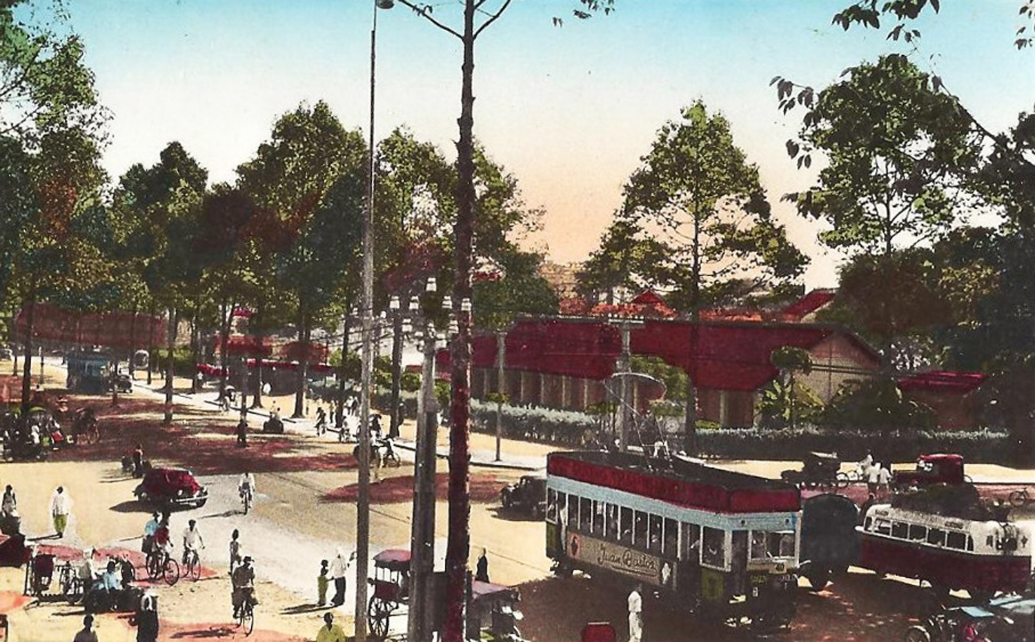
The boulevard Galliéni, now Trần Hưng Đạo boulevard, pictured in the 1940s
This article was published previously in Saigoneer.
One of Saigon’s youngest major boulevards, Trần Hưng Đạo was built in 1911-1913 over former swamp land to provide a more direct route between the cities of Saigon and Chợ Lớn.
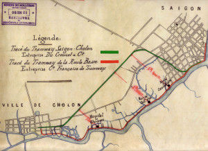
An 1890 map of the “High Road” and (then proposed) “Low Road” tramway routes, which avoided the swamp
For nearly 60 years after the conquest, Saigon and Chợ Lớn were separated by a large expanse of swampy ground known as the Marais Boresse (Boresse Swamp). This particularly inaccessible quagmire was located immediately to the west of modern Nguyễn Thái Học street.
During this period, access between the two cities was achieved by taking either the “High Road” (route Haute) – modern Nguyễn Thị Minh Khai and Trần Phú streets – or the “Low Road” (route Basse), which ran along the north bank of the arroyo Chinois (Bến Nghé creek). It was along these routes that two rival Saigon-Chợ Lớn steam tramways were opened by private operators, in 1881 and 1891 respectively.
In 1879, 1887 and again in 1904, the Cochinchina authorities drew up plans to fill the swamp, but on each occasion these plans had to be abandoned, due to arguments between Colonial Councillors and ultimately shortage of funds.
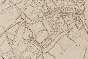
The boulevard Galliéni pictured on a Saigon map of 1918, before the tramway line was installed
Finally on 27 July 1910, following an embarrassing intervention by the exasperated Government General in Hà Nội, the sum of 1,250,000 piastres was set aside for the filling of the marsh, the sinking of foundations for the new Saigon Railway Station and the construction of a brand new road linking the two cities, to be known as the boulevard Saigon-Cholon.
Entrusted to the Société française d’Entreprises de Dragages et de Travaux publics on 18 April 1911, these major works took over two years to complete. The boulevard Saigon-Cholon opened to traffic on 9 December 1913.
Conceived from the outset as an extension of the boulevard Bonnard (modern Lê Lợi boulevard, with which it connected via the square in front of the new Halles centrales or Bến Thành Market), the boulevard Saigon-Cholon extended west as far as the rue d’An-Binh (modern An Bình street), whence the existing rue des Marins (modern Trần Hưng Đạo B) continued into Chợ Lớn

General Joseph Galliéni (24 April 1849-27 May 1916)
In late 1916, following the death of French military commander and colonial administrator General Joseph Galliéni (24 April 1849-27 May 1916), the boulevard Saigon-Cholon was rechristened boulevard Général Galliéni.
By 1911, the operator of the old “High Road” steam tramway, the Société générale des tramways à vapeur de Cochinchine (SGTVC), had been driven out of business by its “Low Road” rival, the Compagnie française des tramways de l’Indochine (CFTI), obliging the government to step in and run the loss-making “High Road” tramway directly as part of its Chemins de fer de l’Indochine (CFI) mainline rail network.
In 1920, as CFTI embarked upon a comprehensive tramway electrification project, CFI briefly considered a proposal to replace the old “High Road” steam tramway with a brand new electric tramway line along boulevard Galliéni. However, it seems that CFI managers had little interest in developing the city tramway and the proposal was abandoned.
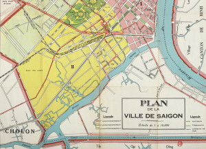
The boulevard Galliéni, pictured on a Saigon map of 1942 which shows the tramway line
Then in 1925, CFI received an offer it simply could not refuse. In that year, CFTI proposed that, in exchange for a 30-year contract extension for all of its operations, it would take over the old Sài Gòn–Chợ Lớn “high road” franchise and, at its own expense, rebuild the line as a 5.9km double-track electric tramway connecting the two cities via the boulevard Galliéni.
The mainline rail operator jumped at this chance to dispense with the loss-making tramway line. A concession was signed in 1926, and the new Galliéni tramway line opened to the public in 1928, with seven stops – Sài Gòn terminus (Hàm Nghi/Hồ Tùng Mậu crossroads), Cuniac (Bến Thành Market), d’Arras (Trần Hưng Đạo/Hồ Hảo Hớn junction), Nancy (Trần Hưng Đạo/Nguyễn Văn Cừ junction), Pétrus Ký (Lê Hồng Phong/Trần Hưng Đạo junction), An-binh (An Bình/Trần Hưng Đạo junction), and then along the rue des Marins into Chợ Lớn.
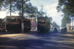
A rare 1953 colour image of electric trams on boulevard Gallieni (Trần Hưng Đạo) boulevard), on the eve of closure
Sadly, the Galliéni boulevard tramway line functioned for only 25 years. Victim of a long-running dispute between CFTI and Bải Đại’s State of Việt Nam government, it ceased operation on 11 June 1953. In 1955, the authorities terminated CFTI’s contract and closed the entire tramway system permanently.
In 1952, the section of Galliéni boulevard running from rue Nancy to rue d’An-Binh was renamed Trần Hưng Đạo boulevard, in honour of the great national hero Trần Hưng Đạo (?-1300), who inflicted three successive defeats on Mongol invaders. Then after 1955, that became the new name of the entire boulevard, while the former rue des Marins which connected it to Chợ Lớn became Đồng Khánh boulevard. Since 1976, Đồng Khánh boulevard has been known as Trần Hưng Đạo B.
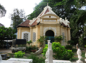
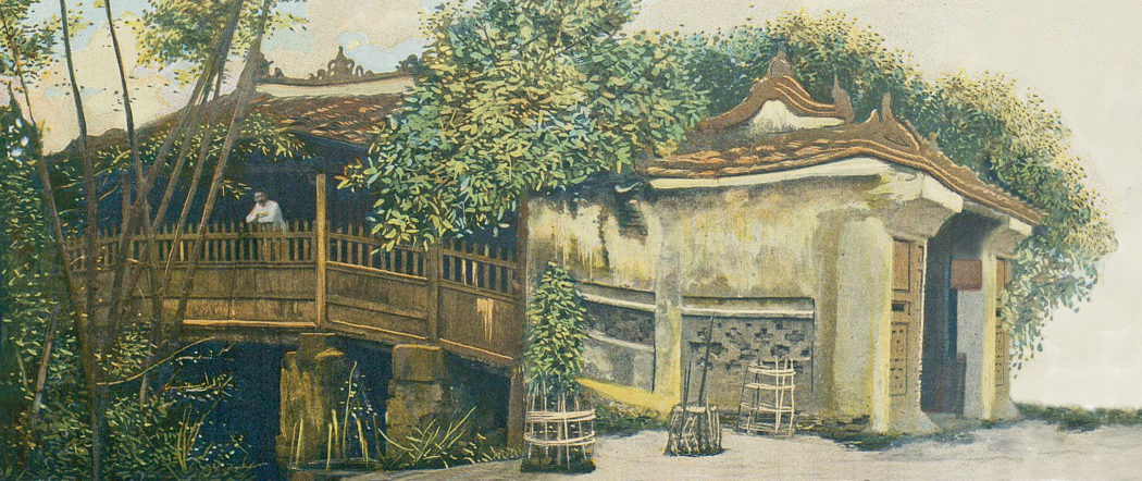
The Pétrus Ký Mausoleum today
After 1955, Trần Hưng Đạo became the new name of the entire boulevard, while the former rue des Marins which connected it to Chợ Lớn became Đồng Khánh boulevard. Since 1976, Đồng Khánh boulevard has been known as Trần Hưng Đạo B.
Because of the street’s relative newness, most of the important landmarks situated along its length date from the later colonial period.
The road was driven through the middle of the former Nhơn Giang village in Chợ Quán, where scholar Pétrus Ký had built his house on 1861, so that when the Pétrus Ký Mausoleum was built on that site in 1935-1937, it stood right next to the boulevard Galliéni.
Other important landmarks on the avenue which still exist include the Comptoir Nguyễn Văn Hảo Saïgonnais flatiron building at 19-21 Trần Hưng Đạo, , the École maternelle de Chodui (now Ernst Thälmann High School) at 8 Trần Hưng Đạo, and the Hakka Clinic (now Hồ Chí Minh City Orthopedic Trauma Hospital) at 929 Trần Hưng Đạo. Sadly the former SAMIPIC mansion at 606 Trần Hưng Đạo , which existed until 2018, has since been demolished.
Tim Doling is the author of the guidebook Exploring Saigon-Chợ Lớn – Vanishing heritage of Hồ Chí Minh City (Nhà Xuất Bản Thế Giới, Hà Nội, 2019)
A full index of all Tim’s blog articles since November 2013 is now available here.
Join the Facebook group pages Saigon-Chợ Lớn Then & Now to see historic photographs juxtaposed with new ones taken in the same locations, and Đài Quan sát Di sản Sài Gòn – Saigon Heritage Observatory for up-to-date information on conservation issues in Saigon and Chợ Lớn.